Yatesbury
| Yatesbury | |
|---|---|
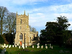
 Church of All Saints, Yatesbury | |
Location within Wiltshire | |
| OS grid reference | SU066716 |
| Civil parish | |
| Unitary authority | |
| Ceremonial county | |
| Region | |
| Country | England |
| Sovereign state | United Kingdom |
| Post town | Calne |
| Postcode district | SN11 |
| Dialling code | 01249 |
| Police | Wiltshire |
| Fire | Dorset and Wiltshire |
| Ambulance | South Western |
| UK Parliament | |
Yatesbury is a small village and former civil parish, now in the parish of Cherhill, in Wiltshire, England. It is in the northeast of Cherhill parish, 1 mile (1.6 km) north of the A4 road approximately 4 miles (6 km) east of Calne and 9 miles (14 km) west of Marlborough.
Yatesbury was an ancient parish and in the 19th century became a civil parish, which was absorbed by Cherhill parish on 1 April 1934.[1][2] In 1931 the parish had a population of 140.[3] Yatesbury today has a population of about 150. Whilst having no shops or amenities, the village is on National Cycle Route 403.[4] It is noted for RAF Yatesbury, which was an important training centre during World War II.
Landmarks
The Church of England parish church of All Saints has 12th-century origins, and 13th-century work can be seen inside; the nave roof and tower are 15th-century. There is a canonical sundial on the south wall. The chancel was rebuilt in 1854 by C.H. Gabriel, and the church was designated as Grade I listed in 1960.[5]
Since 1973[2] the parish has been part of the Oldbury Benefice, which comprises the five parishes of Calstone Wellington, Cherhill, Compton Bassett, Heddington and Yatesbury.[6]
The nearest primary school is at Cherhill. Yatesbury had its own small school from 1856 to 1963; after the school closed the building became the village hall.[7]
The Granary at Manor Farm, Yatesbury, was restored by the Wiltshire Historic Buildings Trust in 2006–2007.[8]
RAF Yatesbury
Opened as a Royal Flying Corps training site in 1916,[9] the station closed three years later and returned to farmland.[10] Pilot training resumed in 1936, then from 1939 the site was used to train many airborne wireless operators and, from 1942, radar operators.[11][12] Training of radar operators, mechanics and fitters continued until 1965;[12] in 1969 the wooden huts were demolished and the land returned again to farming, leaving several brick-built buildings and hangars.[13]
Notable people
The singer, songwriter and author Julian Cope has lived in the village for many years.[14] He referenced the village in the song My Wall in which he collaborated with the American drone metal band Sunn 0))), as well as in his 2013 publication, Copendium.
References
- ^ "Relationships and changes Yatesbury AP/CP through time". A Vision of Britain through Time. Retrieved 28 August 2023.
- ^ a b Crowley, D.A. (ed.). "Victoria County History - Wiltshire - Vol 17 pp172-181 - Yatesbury". British History Online. University of London. Retrieved 25 March 2016.
- ^ "Population statistics Yatesbury AP/CP through time". A Vision of Britain through Time. Retrieved 28 August 2023.
- ^ "Route 403". Sustrans. Retrieved 25 March 2016.
- ^ Historic England. "Church of All Saints, Yatesbury (1363771)". National Heritage List for England. Retrieved 15 July 2015.
- ^ "The Oldbury Benefice". Retrieved 25 March 2016.
- ^ "Yatesbury Church of England School". Wiltshire Community History. Wiltshire Council. Retrieved 25 March 2016.
- ^ Johns, Colin (2007). Wiltshire Historic Buildings Trust 1967–2007 (PDF). p. 30.
- ^ Philpott, Ian (9 December 2013). The Birth of the Royal Air Force. Pen and Sword. p. 258. ISBN 978-1-4738-3170-4.
- ^ Riding, Richard (27 March 2014). A Flying Life: An Enthusiast's Photographic Record of British Aviation in the 1930s. Fonthill Media. p. 215. ISBN 978-1-78155-414-2.
- ^ Philpott, Ian (15 July 2008). The Royal Air Force - Volume 2: An Encyclopedia of the Inter-War Years 1930-1939. Pen and Sword. p. 276. ISBN 978-1-84415-391-6.
- ^ a b Jenkins, Stanley C.; Long, Angela (15 November 2015). Marlborough & Around Through Time. Amberley Publishing Limited. p. 187. ISBN 978-1-4456-4134-8.
- ^ Pugh, Ralph Bernard; Crittall, Elizabeth (1953). A History of Wiltshire. Institute of Historical Research. p. 138. ISBN 978-1-904356-01-1.
- ^ "Address Drudion". Julian Cope Presents Head Heritage. Retrieved 24 August 2019.
External links
![]() Media related to Yatesbury, Wiltshire at Wikimedia Commons
Media related to Yatesbury, Wiltshire at Wikimedia Commons

