Winkel, North Holland
Winkel | |
|---|---|
Village | |
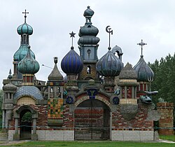
 The Kremlin of Winkel | |
| Coordinates: 52°45′7″N 4°54′13″E / 52.75194°N 4.90361°E | |
| Country | Netherlands |
| Province | North Holland |
| Municipality | Hollands Kroon |
| Area | |
• Total | 10.18 km2 (3.93 sq mi) |
| Elevation | −0.3 m (−1.0 ft) |
| Population (2021)[1] | |
• Total | 3,400 |
| • Density | 330/km2 (870/sq mi) |
| Time zone | UTC+1 (CET) |
| • Summer (DST) | UTC+2 (CEST) |
| Postal code | 1731[1] |
| Dialing code | 0224 |
Winkel is a village in the Dutch province of North Holland. It is a part of the municipality of Hollands Kroon, and lies about 11 km north of Heerhugowaard.
History
The village was first mentioned in 1289 as Winckele, and means "enclosed piece of land".[3] Winkel developed in the Middle Ages as a peat excavation settlement. It was largely destroyed in 1519, and suffered a fire in 1649.[4]
The Dutch Reformed church is an aisleless with needle spire in a neoclassic style. It was built 1845 as a replacement for the medieval church. The tower was rebuilt in 1867.[4] The Kremlin is a garden with follies some of which are over 10 metres (33 ft) tall.[5]
Winkel was home to 660 people in 1840.[5] It was a separate municipality until 1970, when it was merged with Niedorp.[6] In 2012, it became part of the municipality of Hollands Kroon.[5]
Gallery
- Former forge
- Former town hall
- Dutch Reformed church
References
- ^ a b c "Kerncijfers wijken en buurten 2021". Central Bureau of Statistics. Retrieved 30 April 2022.
- ^ "Postcodetool for 1731LJ". Actueel Hoogtebestand Nederland (in Dutch). Het Waterschapshuis. Retrieved 30 April 2022.
- ^ "Winkel - (geografische naam)". Etymologiebank (in Dutch). Retrieved 30 April 2022.
- ^ a b Ronald Stenvert & Saskia van Ginkel-Meester (2006). "Winkel" (in Dutch). Zwolle: Waanders. Retrieved 30 April 2022.
- ^ a b c "Winkel". Plaatsengids (in Dutch). Retrieved 30 April 2022.
- ^ Ad van der Meer and Onno Boonstra, Repertorium van Nederlandse gemeenten, KNAW, 2011.


