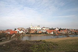
Vysoké Veselí
Vysoké Veselí | |
|---|---|
 Panorama of Vysoké Veselí | |
| Coordinates: 50°19′58″N 15°26′23″E / 50.33278°N 15.43972°E | |
| Country | |
| Region | Hradec Králové |
| District | Jičín |
| First mentioned | 1283 |
| Government | |
| • Mayor | Luboš Holman |
| Area | |
• Total | 9.34 km2 (3.61 sq mi) |
| Elevation | 254 m (833 ft) |
| Population (2024-01-01)[1] | |
• Total | 869 |
| • Density | 93/km2 (240/sq mi) |
| Time zone | UTC+1 (CET) |
| • Summer (DST) | UTC+2 (CEST) |
| Postal code | 507 03 |
| Website | www |
Vysoké Veselí is a town in Jičín District in the Hradec Králové Region of the Czech Republic. It has about 900 inhabitants.
Administrative parts
The village of Veselská Lhota is an administrative part of Vysoké Veselí.
Geography
Vysoké Veselí is located about 13 kilometres (8 mi) south of Jičín and 30 km (19 mi) northwest of Hradec Králové. It lies in the East Elbe Table. The highest point is at 908 m (2,979 ft) above sea level. The Cidlina River flows through the town. The town proper is situated between two fishponds called Vysokoveselský and Šmejkal.
History
The first written mention of Vysoké Veselí is from 1283, when it was already a market town, owned by the Wartenberg family. They owned it until 1438, then the estate was split and only a few of the nearest villages were managed from Vysoké Veselí. The owners often changed until 1533, when the Dohalský of Dohalice family acquired Vysoké Veselí by marriage. They enlarged the estate and had rebuilt the local fortress into a Renaissance residence.[2]
In 1627–1634, Vysoké Veselí was property by Albrecht von Wallenstein, then it was acquired by Heřman Nidrum of Šardek. The Dohalský of Dohalice family owned the market town once again in 1654–1672. In the second half of the 17th century, during the rule of the Záruba of Hustířany family, Vysoké Veselí ceased to be the centre of the estate and the fortress fell into disrepair.[2]
In the 19th century, Vysoké Veselí was industrialized. In 1908, it was promoted to a town by Emperor Franz Joseph I.[2]
Demographics
|
|
| ||||||||||||||||||||||||||||||||||||||||||||||||||||||
| Source: Censuses[3][4] | ||||||||||||||||||||||||||||||||||||||||||||||||||||||||
Transport
There are no railways or major roads running through the municipal territory.
Sights

The main landmark of Vysoké Veselí is the Church of Saint Nicholas of Tolentino. It was originally a Baroque building from 1770, but it was destroyed by a fire in 1835. In 1835–1840, the church was completely rebuilt in the Empire style.[2][5]
The former fortress was rebuilt into a Baroque castle in 1745. it was also damaged by the 1835 fire and rebuilt in the Empire style. In 1950–1974, the building was adapted to a school and lost its architectural value. It serves as a kindergarten today.[2]
Notable people
- Friedrich Franz (1783–1860), mathematician and priest
- Václav Šimerka (1819–1887), mathematician and priest
References
- ^ "Population of Municipalities – 1 January 2024". Czech Statistical Office. 2024-05-17.
- ^ a b c d e "Historie Vysokého Veselí a blízkého okolí" (in Czech). Město Vysoké Veselí. Retrieved 2023-12-05.
- ^ "Historický lexikon obcí České republiky 1869–2011" (in Czech). Czech Statistical Office. 2015-12-21.
- ^ "Population Census 2021: Population by sex". Public Database. Czech Statistical Office. 2021-03-27.
- ^ "Kostel sv. Mikuláše Tolentinského" (in Czech). National Heritage Institute. Retrieved 2023-12-05.


