User talk:CaoimhghinOCionnfhaolaidh
Irish counties table
Work in progress.
|

|
CaoimhghinOCionnfhaolaidh 21:09, 15 April 2007 (UTC)
Hi. This looks good to me; I presume Laois isn't annexing its neighbours! The population of Dublin is missing the odd million or so, but apart from that quibble it looks very well; and is informative and clear. Regards (Sarah777 00:20, 16 April 2007 (UTC))
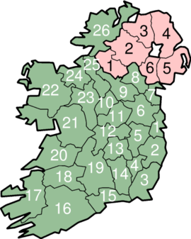
While you're at it maybe you could do something about the map with the numbers - it looks ugly. (I know it isn't your - it came from the Ireland page)(Sarah777 00:56, 16 April 2007 (UTC))
- I'll have a look at the map after I've finished this table, Sarah. CaoimhghinOCionnfhaolaidh 01:03, 16 April 2007 (UTC)
Looks quite good. Only quibble would be that the 'new' counties - Fingal, South Co. Dublin, etc. - have their own coats of arms too. Also, by, say, bolding the cities with councils, you could incorporate the full set of administrative divisions in the country into the one table? BastunBaStun not BaTsun 09:58, 16 April 2007 (UTC)
- Sounds like a plan, do you know of any full list of admin divisions? CaoimhghinOCionnfhaolaidh 13:15, 16 April 2007 (UTC)
- Sorry, missed your question. Basically there are 29 county councils (Tipperary split into North and South, Dublin split into South County Dublin, Fingal and Dun Laoghaire-Rathdown) and 5 city councils - Dublin, Cork, Limerick, Waterford, and Galway - making 34 administrative divisions in total. See here [1] for more. BastunBaStun not BaTsun 13:29, 19 April 2007 (UTC)
Hi Caoimhghin. Just a quick question. (As it may influence some recommendations for improvement). What are you planning to do with this table/template when you're done? Add it to the Counties section to replace the current map? Replace the map and/or alphabetical list on Counties of Ireland? Include this template in List of Irish counties by area, or population? Create an entirely new article? Equivalent to Counties of Northern Ireland? Or something else?
- I'm planing to replace the current list of counties on the ROI page first, and then perhaps do the same for Counties of Ireland, and the other pages you mentioned. I'm certainly not wanting to create a new article. CaoimhghinOCionnfhaolaidh 13:15, 16 April 2007 (UTC)
If it's the first option, then - well - my main point of feedback is: The table might be a bit big in it's current form. Guliolopez 11:58, 16 April 2007 (UTC)
- I'll see what I can do to make it smaller. CaoimhghinOCionnfhaolaidh 13:15, 16 April 2007 (UTC)
- This was going to be my comment too - maybe its a good place for the
<small>tag. Some other questions: you included Dublin City Council without including the other burough councils, is there a reason for this? If you could integrate the map and the table, I think it could be better too (since the map really is an integral part of the table) - may be in the first column which could run for the full length of the table. For the issue of the "new conuties" having to be included in some traditional counties, maybe you could split the rows from the second column onwards (so the current numbering is the same), have a subheading for "New Counties" or "Includes" or so forth, then show each of the "new counties" as per usual. The "main"/"traditional county" could show the traditinoal crest and total population. The county buroughs could be integrated in this way also. - Those are my ideas for now. Great work! I had been thinking of doing something like this before but passed it over just 'cos I knew how hard it would be. You did a great job!--sony-youthpléigh 07:39, 24 April 2007 (UTC)
- Here is my attempt at splitting the columns I have no idea where the county buroughs would go though. --Barryob Vigeur de dessus 00:52, 27 April 2007 (UTC)
- This was going to be my comment too - maybe its a good place for the
Hello, CaoimhghinOCionnfhaolaidh. An automated process has found and removed an image or media file tagged as nonfree media, and thus is being used under fair use that was in your userspace. The image (Image:Countyclare-crest.png) was found at the following location: User talk:CaoimhghinOCionnfhaolaidh. This image or media was attempted to be removed per criterion number 9 of our non-free content policy. The image or media was replaced with Image:NonFreeImageRemoved.svg , so your formatting of your userpage should be fine. Please find a free image or media to replace it with, and or remove the image from your userspace. User:Gnome (Bot)-talk 22:57, 15 May 2007 (UTC)
