User:Sadalmelik
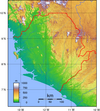
Maps  I've been mostly messing around creating topographic maps with GMT for islands and countries and islands. My early maps for islands in Melanesia and Asian countries need to be redone (the colours are ugly), but I think the African maps are reasonably pretty. Green colour is too green/bright still, though. I have created topographic maps of all the African states with colours light enough to allow adding labels (see below for Somalian map), but I ran out of steam... Need maps?I am also happy to help, if you need a map or two. Strictly speaking, I don't really understand what I'm doing... but then, the best way of learning something is doing it. Too darn bad that I keep changing my mind about the colour scheme to use, and continue uploading new versions. Depending on the scale, I have either used SRTM or GLOBE data. GalleryFull vanity gallery can be found at Commons. | ||||||||||||||||||||||||||||||||
Commons  I have recently also become more active on Commons, where I have been categorizing images and hunting for suitable images from Flickr. FIST is a usefull tool, but only finds freely usable Flickr images. Typically there are many more images with ©-tag than free images, which means rare subjects and high quality images are more likely finds among the copyrighted images and the free ones. There is always a possibility that the photographer might agree to change the license, though. Nifty tools
| ||||||||||||||||||||||||||||||||
Sockpuppy FrankenpuppyI have a sockpuppy account, Frankenpuppy, which is used with Huggle and also occasionally for AWB runs. | ||||||||||||||||||||||||||||||||
Barnstars
|


