Triangle (Israel)


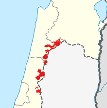
The Triangle (Hebrew: המשולש, HaMeshulash; Arabic: المثلث, al-Muthallath), formerly referred to as the Little Triangle, is a concentration of Israeli Arab towns and villages adjacent to the Green Line, located in the eastern Sharon plain among the Samarian foothills; this area is located within the easternmost boundaries of both the Central District and Haifa District. The eleven towns are home to approximately 250,000 Arab citizens of Israel, representing between 10-15% of Israel's Palestinian Arab population.[2]
The Triangle is further divided into the "Northern Triangle" or Wadi Ara[3] (around Kafr Qara, Ar'ara, Baqa al-Gharbiyye, Zemer and Umm al-Fahm) and the "Southern Triangle" (around Qalansawe, Tayibe, Kafr Qasim, Tira, Kafr Bara and Jaljulia). Umm al-Fahm and Tayibe are the social, cultural and economic centers for Arab residents of the region. The Triangle is a stronghold of the Islamic Movement in Israel and Raed Salah, the current leader of the movement's northern faction, is a former mayor of Umm al-Fahm.
History and status
Prior to the 1948 Arab–Israeli War and Israel's establishment and sovereignty over the Kafr Qasim, Jaljulia and Kafr Bara area, it was referred to as the "Little Triangle" to differentiate it from the original larger "Triangle" region between Jenin, Tulkarm, and Nablus.[1] The original triangle was dubbed by the British the "Triangle of Terror" or "Triangle of Fear", during the 1936–1939 Arab revolt in Palestine.[1]
The region was originally designated to fall under Jordanian jurisdiction, but while negotiating the 1949 Armistice Agreements, Israel insisted on having it within its side of the Green Line, for military and strategic reasons. To achieve this, a territorial swap was negotiated, ceding the Israeli territory in the southern hills of Hebron in exchange for the Triangle villages in Wadi Ara.[4][5] The term was later expanded to include the entire area around Wadi Ara (the Northern Triangle of today) and the "Little" appendage quickly fell out of common use.
Populations as of 2022 are as follows:[6]
- Umm al-Fahm: 58,665
- Tayibe: 46,020
- Baqa al-Gharbiyye: 31,397
- Ar'ara: 26,147
- Kafr Qasim: 25,285
- Qalansawe: 24,205
- Kafr Qara: 20,018
- Jaljulia: 10,609
- Zemer: 7,457
- Kafr Bara: 3,946
Involuntary loss of citizenship
The concept of stripping the citizens of the area of their citizenship of Israel has been mooted. Several Israeli politicians have suggested the Triangle should be transferred to a future Palestinian state in exchange for Israel retaining control over settlements in the West Bank. The idea is a major part of the Lieberman Plan put forward by Yisrael Beiteinu leader Avigdor Lieberman but is largely opposed by Israeli Arabs.[7] It is also a key feature of the Trump peace plan, which stated:
The Triangle Communities consist of Kafr Qara, Ar’ara, Baha al-Gharbiyye, Umm al Fahm, Qalansawe, Tayibe, Kafr Qasim, Tira, Kafr Bara and Jaljulia. These communities, which largely self-identify as Palestinian, were originally designated to fall under Jordanian control during the negotiations of the Armistice Line of 1949, but ultimately were retained by Israel for military reasons that have since been mitigated. The Vision contemplates the possibility, subject to agreement of the parties that the borders of Israel will be redrawn such that the Triangle Communities become part of the State of Palestine. In this agreement, the civil rights of the residents of the triangle communities would be subject to the applicable laws and judicial rulings of the relevant authorities.[8]
In a July 2000 survey conducted by Kul al-Arab among 1,000 residents of Umm al-Fahm, 83 percent of respondents opposed the idea of transferring their city to Palestinian jurisdiction.[9]
See also
References
- ^ a b c Makdisi, Ussama Samir; Silverstein, Paul A. (2006). Memory and Violence in the Middle East and North Africa. Indiana University Press. pp. 125–. ISBN 978-0-253-21798-1.
The "Little Triangle" forms the narrow Israeli-held strip of the larger district circumscribed by the three West Bank cities of Nablus, Tulkarm, and Jenin. During the Arab Revolt from 1936 to 1939 this district was the center of rebel activity and became known by the British as the "Triangle of Terror"
- ^ Report: Netanyahu suggested to US that Arab Israeli towns be placed in Palestine, Times of Israel, 4 February 2020
- ^ Hillel Cohen (6 January 2010). Good Arabs: The Israeli Security Agencies and the Israeli Arabs, 1948–1967. University of California Press. p. 15. ISBN 978-0-520-94488-6.
... the villages of Wadi Ara (the area called the northern Triangle)...
- ^ Yisrael Ya'akov Yuval, "Where is the Green Line", Two Thousand, Vol. 29, no. 971, 2005 (in Hebrew)
- ^ Akiva Eldar (21 July 2006). "What is the Green Line". Haaretz (in Hebrew). Archived from the original on 5 June 2011.
- ^ "Regional Statistics". Israel Central Bureau of Statistics. Retrieved 21 March 2024.
- ^ Fadi Eyadat (12 March 2007). "New poll shows 68.4% of Israeli Jews fear Israeli Arab uprising". Haaretz. Retrieved 21 August 2014.
- ^ File:Peace to Prosperity.pdf
- ^ Kul Al-Arab (Nazareth, Israel), 28 July 2000, cited in Joseph Algazy (1 August 2000). "Um Al-Fahm Prefers Israel". Haaretz. archived at "Israeli Arabs Prefer Israel to Palestinian Authority". MEMRI. 10 August 2000.

