Frome Street
Froe Street | |
|---|---|
 | |
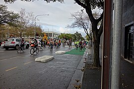
| Cyclists on Frome Street, including the Bikeway (2014) | |
 | |
| Coordinates | |
| General information | |
| Type | Street |
| Location | Adelaide city centre |
| Length | 1.1 km (0.7 mi)[1] |
| Opened | 1962 |
| Major junctions | |
| North end | Frome Road Adelaide |
| South end | Carrington Street Adelaide |
| Location(s) | |
| LGA(s) | City of Adelaide |
Frome Street is a street in the East End of the Adelaide city centre, South Australia. It runs from North Terrace in the north to Angas Street, and then as Regent Street North to Carrington Street in the south. North of North Terrace, Frome Street continues towards North Adelaide as Frome Road.
Built in the early 1960s, the street was named after Edward Charles Frome, who was Surveyor General of South Australia for most of the 1840s.
History

Frome Street was not part of the William Light's plan for Adelaide, and did not exist as a main street until the 1960s. It has a disjointed and winding structure compared to the planned arterial roads. The 1960s Adelaide City Council planned Frome Street to extend from Frome Road as part of a link from Main North Road to Glen Osmond Road, to relieve traffic congestion in King William Street. The development of the street had commenced by 1962, widening Tavistock Street (North Terrace to Rundle Street) and Ackland Street (Grenfell Street to Wakefield Street) and purchasing properties in between.[2]
In the 1970s the state government halted the development, so the street only extends part way across the city centre.[2][3]
Frome Road, of which Frome Street is a continuation, was named after Edward Charles Frome, Surveyor-General for most of the 1840s.[4]
Frome Street Bikeway
In 2014, the southern part of Frome Street was modified to create separated bike lanes between the parallel car parking and the footpath. These lanes connect with minor laneways to the south and a path across the Adelaide Parklands as the Frome Street Bikeway. By June 2014, the separated bike lanes extended as far north as Pirie Street, with community consultation yet to occur for extension further north.[5] In 2017–18, the bikeway was extended to Grenfell Street (completed February 2018), and part of what had already been built was removed and relaid to match.[6]
There were some calls to remove the city's first separated bikeway, but after the Adelaide Design Manual was produced, followed by the Bikeways Design Guide, the state government gave the City a A$6 million grant to help it rebuild the Frome Street bikeway as well as a new east–west cycling corridor. The City matched the amount for its own spend on the project.[7]
As of December 2019, the Frome Street Bikeway is being integrated into the North-South Bikeway, which is "build[ing] on the existing Frome Bikeway and will connect the existing Rugby/Porter Bikeway in Unley to the Braund Road Bike Boulevard in Prospect". The Rundle Street to Greenhill Road section has been completed.[8]
References
- ^ "Frome Street" (Map). Google Maps. Retrieved 1 June 2022.
- ^ a b David Washington (23 April 2014). "Frome St: The road to nowhere". InDaily. Solstice Media. Retrieved 16 June 2014.
- ^ Llewellyn-Smith, Michael (2012). Behind the Scenes: The Politics of Planning Adelaide. University of Adelaide Press. p. 88. ISBN 9781922064400.
- ^ Manning, Geoffrey H. (2012). "Nomenclature of the Streets of Adelaide and North Adelaide" (PDF). State Library of South Australia A Compendium of the Place Names of South Australia. Retrieved 25 May 2021.
- ^ "Frome Street Bikeway". Adelaide City Council. Retrieved 16 June 2014.
- ^ "City Bikeways". Your Future Adelaide. City of Adelaide. Archived from the original on 27 March 2018. Retrieved 27 March 2018.
- ^ "It's not just about bikes". Bicycle Network. 13 August 2019. Retrieved 9 December 2019.
- ^ "City bikeways". City of Adelaide. Retrieved 9 December 2019.

