Tamahú
Tamahú | |
|---|---|
| San Pablo Tamahú | |
| Coordinates: 15°18′25″N 90°14′3″W / 15.30694°N 90.23417°W | |
| Country | |
| Department | |
| Climate | Af |
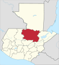
Tamahú is a municipality in the Guatemalan department of Alta Verapaz.
History
Tamahú was established on 7 December 1574 by friars Francisco de Viana, Lucas Gallego and Fray Guillermo.[1]
One of the most powerful German families that settled in the region by the end of the 19th century was the Thomae family, who had their headquarters in neighbor Purulhá. Mauricio Thomae's early farmland were the following haciendas:[2]
| Year | Hacienda | Location |
|---|---|---|
| 1882 | Cubilgüitz | Cobán |
| 1889 | San Isidro | Purulhá |
| 1897 | Comija | Tamahú |
| 1897 | Popabaj | Tucurú |
| 1900 | Nueve Aguas | Purulhá |
| 1902 | Panzal | Purulhá |
| 1902 | Rocjá | Tamahú |
| 1902 | Paijá | Tucurú |
| 1905 | Chimox | Tucurú[2] |
Years later, during Jorge Ubico's presidency (1931-1944), Thomae went on to become one of the most influential landlords in the German Verapaz, along with the Sarg, Sapper and Diesseldorf families. Ubico had been governor of Cobán during Manuel Estrada Cabrera 22-year regime and befriended several German families, including the Thomaes.[2]
Climate
Tamahú has a tropical rainforest climate (Köppen: Af).
| Climate data for Tamahú | |||||||||||||
|---|---|---|---|---|---|---|---|---|---|---|---|---|---|
| Month | Jan | Feb | Mar | Apr | May | Jun | Jul | Aug | Sep | Oct | Nov | Dec | Year |
| Mean daily maximum °C (°F) | 24.4 (75.9) |
25.7 (78.3) |
27.1 (80.8) |
28.1 (82.6) |
28.0 (82.4) |
26.2 (79.2) |
26.7 (80.1) |
26.5 (79.7) |
25.8 (78.4) |
24.8 (76.6) |
24.2 (75.6) |
20.9 (69.6) |
25.7 (78.3) |
| Daily mean °C (°F) | 18.6 (65.5) |
19.4 (66.9) |
20.9 (69.6) |
22.1 (71.8) |
22.5 (72.5) |
22.3 (72.1) |
21.8 (71.2) |
21.9 (71.4) |
21.8 (71.2) |
21.1 (70.0) |
20.0 (68.0) |
18.9 (66.0) |
20.9 (69.7) |
| Mean daily minimum °C (°F) | 12.8 (55.0) |
13.1 (55.6) |
14.8 (58.6) |
16.1 (61.0) |
17.0 (62.6) |
17.8 (64.0) |
17.5 (63.5) |
17.2 (63.0) |
17.1 (62.8) |
16.4 (61.5) |
15.2 (59.4) |
13.7 (56.7) |
15.7 (60.3) |
| Average precipitation mm (inches) | 84 (3.3) |
68 (2.7) |
67 (2.6) |
77 (3.0) |
189 (7.4) |
393 (15.5) |
361 (14.2) |
269 (10.6) |
371 (14.6) |
279 (11.0) |
145 (5.7) |
91 (3.6) |
2,394 (94.2) |
| Source: Climate-Data.org[3] | |||||||||||||
Geographic location
Tamahú is practically surrounded by Alta Verapaz Department municipalities:[4]
References
- ^ Escalante Herrera, Marco Antonio (2010). "Tamahú". Pbase. Guatemala. Archived from the original on May 30, 2010. Retrieved 26 August 2015.
- ^ a b c "Nepotismo y la decadencia de la familia Thomae". Centro de Medios Independiente de Guatemala (in Spanish). Guatemala. 20 July 2015. Archived from the original on August 8, 2015. Retrieved 7 August 2015.
- ^ "Climate: Tamahú". Climate-Data.org. Retrieved 26 August 2015.
- ^ a b c SEGEPLAN. "Municipios de Alta Verapaz, Guatemala". Secretaría General de Planificación y Programación de la Presidencia de la República. Guatemala. Archived from the original on 30 June 2015. Retrieved 30 June 2015.


