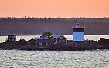
Svartklubben
 | |
 | |
| Location | East of Singö Åland Sea Sweden |
|---|---|
| Coordinates | 60°10′28″N 18°49′30″E / 60.174413°N 18.824993°E |
| Tower | |
| Constructed | 1820 |
| Construction | stone tower |
| Automated | 1961 |
| Height | 12 metres (39 ft) |
| Shape | massive cylindrical tower with gallery and lantern |
| Markings | white tower with a black band on the top |
| Power source | bituminous coal, rapeseed oil, kerosene, electricity |
| Operator | Swedish Maritime Administration (Sjöfartsverket)[1] |
| Heritage | governmental listed building complex, governmental listed building |
| Racon | K |
| Light | |
| First lit | 1920 |
| Focal height | 19.5 metres (64 ft) |
| Lens | open fire (original), 4th order Fresnel lens (1899) |
| Range | 16 nautical miles (30 km; 18 mi) |
| Characteristic | LFl (2) WRG 15s. |
| Sweden no. | SV-2228 |
Svartklubben is a Swedish lighthouse located on a small island east of the island Singö in the province of Uppland.
This massive lighthouse was constructed to carry a coal fire. In 1842 it was updated with a colza oil lamp and in 1849 parabolic mirrors were installed. In 1875 it was updated with a kerosene lamp, and in 1899 the current lens and lantern were installed. It got a gas mantle light in 1935, and was finally electrified and automated in 1961. The keeper's house is now sold as a private residence, but the Swedish Maritime Administration still owns and maintains the lighthouse.
The lighthouse has been a listed building in Sweden since 1935.
See also
References
- ^ Rowlett, Russ. "Lighthouses of Sweden: Stockholm Area". The Lighthouse Directory. University of North Carolina at Chapel Hill. Retrieved 2016-04-07.
- Rowlett, Russ. "Lighthouses of Sweden: Stockholm Area". The Lighthouse Directory. University of North Carolina at Chapel Hill. Retrieved 1 September 2012.
- https://web.archive.org/web/20120314190711/http://www.fyr.org/indexe.htm
External links
- Sjofartsverket Archived 2016-04-08 at the Wayback Machine (in English)
- The Swedish Lighthouse Society
