Sumapaz River
| Sumapaz River | |
|---|---|
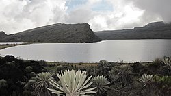
 Lake Chisacá, source of the river | |
| Native name | Río Sumapaz (Spanish) |
| Location | |
| Country | Colombia |
| Physical characteristics | |
| Source | |
| • location | Lake Chisacá, Sumapaz Páramo |
| • coordinates | 4°16′51″N 74°12′25.4″W / 4.28083°N 74.207056°W |
| • elevation | 4,710 m (15,450 ft)[1] |
| Mouth | |
• location | Ricaurte |
• coordinates | 4°15′51″N 74°46′50″W / 4.264257°N 74.780632°W |
• elevation | 289 m (948 ft) |
| Length | 95 km (59 mi) |
| Basin size | 480 km2 (190 sq mi) |
| Basin features | |
| River system | Magdalena River Caribbean Sea |
| Tributaries | |
| • left | Pilar River, San Juan River, Cuja River, Panches River |
The Sumapaz River (Spanish: Río Sumapaz) is a major tributary of the Magdalena River in Colombia. The 95 kilometres (59 mi) long river originates in the Eastern Ranges of the Colombian Andes at the largest páramo in the world; Sumapaz, of which it takes its name. It forms the natural boundary between the departments of Cundinamarca and Tolima.
Course
The Sumapaz River flows through the Magdalena Valley montane forests ecoregion in its upper reaches.[2] The Sumapaz River flows through the department of Cundinamarca. It takes its name from its place of birth in the Sumapaz Páramo, the largest páramo in the world, in the rural zone of Bogotá.[3] It is one of the main tributaries of the upper course of the Magdalena River[4]
In ancient times, it was known as the Fusagasugá River, with a length of 200 kilometres (120 mi). The lower reaches of the Fusagasugá River become the Sumapaz after the confluence of the Chocho and Cuja. The river and its tributaries, the Gobernador, Bejucal, San Juan, Negro, Guavio, Batán, Juan Viejo, Corrales, Bosque, Colorado, Barroblanco, Subia or Chocho, Panches and Pagüey all originate in the Sumapaz and San Fortunato páramos, apart from the Pagüey.[5] The Fusagasugá valley is known for its pleasant climate and the surrounding hills.[6] There was a 100 square kilometres (39 sq mi) Fusagasugá Lagoon, which probably drained through the Melgar Valley.[7] The river crosses the municipalities of Cabrera, Venecia, Pandi, Icononzo, Nilo, Melgar and Ricaurte. It forms the natural boundary between the departments of Tolima and Cundinamarca.
Physical and natural aspects
The Sumapaz River can be divided into three sections: source, middle and lower valley. The source is in the Sumapaz Páramo, the world's largest páramo, and one of the most important sources of water, supplying the southern part of the Cundinamarca and important towns in the Tolima department. The middle course of the river drops from 4,710 to 289 metres (15,453 to 948 ft) above sea level before reaching the lower valley formed by the river in the municipality of Melgar, which extends to its mouth on the Magdalena River in the municipality of Ricaurte.
Tourism
The municipalities of Pandi, Melgar and Ricaurte are in the lower valley. These hold vacation spots for the people of the capital of Colombia, Bogotá, drawn by the warm climate and important tourist sites and hotels. In recent years, adventure sports like river rafting have become popular.
The Icononzo natural bridge is an important natural attraction, a geological formation of great beauty and complexity that was once visited by the German naturalist Alexander von Humboldt and that was once considered one of the hundred natural wonders of the world.[8][9]
Future hydroelectric project
Since 2010, the power generation company Emgesa, a subsidiary of the Italian company Enel, has been conducting pre-feasibility and feasibility studies for construction of eight small hydroelectric power plants along the 50 kilometres (31 mi) stretch of the Sumapaz between the mouth of the San Juan River and the Las Lajas gorge, in the municipalities of Cabrera, Venice and Pandi in the department of Cundinamarca, and the municipality of Icononzo in Tolima.[10]
See also
References
- ^ (in Spanish) Corporación Autonoma Regional Del Tolima, CORTOLIMA Archived 2007-07-29 at the Wayback Machine
- ^ Constantino.
- ^ William Alberto Zorro 2005.
- ^ (in Spanish) Río Magdalena
- ^ Pérez 1863, p. 116.
- ^ Pérez 1863, p. 142.
- ^ Pérez 1863, p. 143.
- ^ Enrique Pérez Arbeláez 1981.
- ^ Sir Richard Phillips 1821, p. 199.
- ^ Viviana Londoño Calle 2012.
Bibliography
- Constantino, Emilio, Northern South America: Western Colombia, WWF, retrieved 2017-06-15
- Enrique Pérez Arbeláez (1981), Alejandro de Humboldt en Colombia: extractos des sus obras compilados, ordenados y prologados, con ocasión del centenario de su muerte en 1859, Biblioteca básica colombiana, vol. 47, Instituto Colombiano de Cultura, División de Publicaciones
- Pérez, Felipe (1863), Jeografia fisica i politica de los Estados Unidos de Colombia: Las jeografías de los estados del Tolima, Cundinamarca, Boyacá, Santander, Bolívar i el Magdalena, Bogotá: Imprenta de la Nación
- Sir Richard Phillips (1821), The hundred wonders of the world: and of the three kingdoms of nature, described according to the latest and best authorities, J. Babcock and Son
- Viviana Londoño Calle (21 July 2012), "El proyecto hidroeléctrico del Sumapaz", Diario El Espectador, retrieved 2017-06-16
- William Alberto Zorro (2005), Plan de Manejo Parque Nacional Natural Sumapaz (PDF), retrieved 2017-06-16


