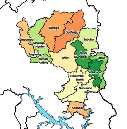
Savelugu-Nanton Municipal District
Savelugu-Nanton Municipal District | |
|---|---|
Former Municipal District | |
 Districts of Northern Region | |
Location of Savelugu-Nanton Municipal District within Northern | |
| Coordinates: 9°37′26.4″N 0°49′40.8″W / 9.624000°N 0.828000°W | |
| Country | |
| Region | Northern |
| Capital | Savelugu |
| Government | |
| • District Executive | Abdullah Red |
| Area | |
• Total | 1,790 km2 (690 sq mi) |
| Time zone | UTC+0 (GMT) |
| ISO 3166 code | GH-NP-SN |
Savelugu-Nanton Municipal District is a former district that was located in Northern Region, Ghana.[1] Originally created as an ordinary district assembly in 1988; which was created from the former West Dagomba District Council. It was later elevated to municipal district assembly status on 1 March 2012. However on 28 June 2012, it was split off into two new districts: Savelugu Municipal District (capital: Savelugu) and Nanton District (capital: Nanton). The municipality was located in the eastern part of Northern Region and had Nanton as its capital town.
Background
Savelugu-Nanton Municipal District had 149 communities, of which five were area councils, aside Savelugu being the capital. The area councils were Nanton, Pong-Tamale, Diare, Moglaa and Tampion. The population of this district according to the 2000 population census was 91,415 having a growth rate of 3%. 109,442 was the projected population as at March 2006 with its breakdown being 49% male and 51% female with a land area of 1790.7 km2.
Localities
External links
References

