Sainte-Angèle-de-Prémont
Sainte-Angèle-de-Prémont | |
|---|---|
 | |
 Location within Maskinongé RCM. | |
| Coordinates: 46°22′N 73°03′W / 46.367°N 73.050°W[1][2] | |
| Country | Canada |
| Province | Quebec |
| Region | Mauricie |
| RCM | Maskinongé |
| Constituted | August 28, 1917 |
| Government | |
| • Mayor | Barbara Paillé |
| • Federal riding | Berthier—Maskinongé |
| • Prov. riding | Maskinongé |
| Area | |
• Total | 37.80 km2 (14.59 sq mi) |
| • Land | 37.73 km2 (14.57 sq mi) |
| Population (2021)[4] | |
• Total | 631 |
| • Density | 16.7/km2 (43/sq mi) |
| • Pop 2016-2021 | |
| • Dwellings | 349 |
| Time zone | UTC−05:00 (EST) |
| • Summer (DST) | UTC−04:00 (EDT) |
| Postal code(s) | |
| Area code | 819 |
| Highways | |
| Website | www |
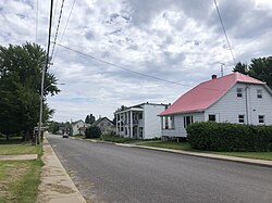
Sainte-Angèle-de-Prémont (French pronunciation: [sɛ̃t ɑ̃ʒɛl də pʁemɔ̃]) is a municipality in Maskinongé Regional County Municipality (RCM), in the Mauricie, region of the province of Quebec, in Canada.
The economy of this municipality is mainly focused on forestry and agriculture.
References
- ^ "Sainte-Angèle-de-Prémont". Geographical Names Data Base. Natural Resources Canada.
- ^ "Banque de noms de lieux du Québec: Reference number 205672". toponymie.gouv.qc.ca (in French). Commission de toponymie du Québec.
- ^ a b "Répertoire des municipalités: Geographic code 51055". www.mamh.gouv.qc.ca (in French). Ministère des Affaires municipales et de l'Habitation.
- ^ a b "Profile table, Census Profile, 2021 Census of Population - Sainte-Angèle-de-Prémont, Municipalité (MÉ) [Census subdivision], Quebec". 9 February 2022.

