Sarthe (river)
| Sarthe | |
|---|---|
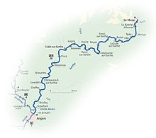
 The navigable river Sarthe between Morannes and Chemiré-sur-Sarthe | |
 | |
| Native name | La Sarthe (French) |
| Location | |
| Country | France |
| Physical characteristics | |
| Source | |
| • location | Perche |
| • elevation | 250 m (820 ft) |
| Mouth | |
• location | Maine |
• coordinates | 47°29′35″N 0°32′34″W / 47.49306°N 0.54278°W |
| Length | 313.9 km (195.0 mi) |
| Basin size | 7,864 km2 (3,036 sq mi)* |
| Discharge | |
| • average | 80 m3/s (2,800 cu ft/s)* |
| Basin features | |
| Progression | Maine→ Loire→ Atlantic Ocean |
| Notes | *excluding Loir |
The Sarthe (French pronunciation: [saʁt] ⓘ) is a 313.9-kilometre-long (195.0 mi) river in western France.[1] Together with the river Mayenne it forms the river Maine, which is a tributary to the river Loire.
Its source is in the Orne department, near Moulins-la-Marche. It flows generally southwest, through the following departments and towns:
- Orne: Le Mêle-sur-Sarthe, Alençon
- Sarthe: Fresnay-sur-Sarthe, Beaumont-sur-Sarthe, Le Mans, Sablé-sur-Sarthe
- Maine-et-Loire: Châteauneuf-sur-Sarthe, Tiercé, Angers
Its main tributaries are the Loir and the Huisne from the left, and the Vaige, the Erve and the Vègre from the right.[1]


Navigation
The Sarthe has 20 weirs and locks.[citation needed] The channel is well marked and navigation is straightforward, except for the risk of shoals in certain sections.
References
External links
- River Sarthe with further maps and expanded details (by the author of 'Inland Waterways of France')
- Navigation details for 80 French rivers and canals (French waterways website section)
