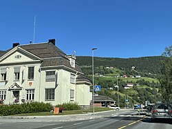
Ringebu (village)
Ringebu Vålebru / Vålebrua | |
|---|---|
Village | |
 View of the village | |
| Coordinates: 61°31′47″N 10°08′20″E / 61.52965°N 10.13889°E | |
| Country | Norway |
| Region | Eastern Norway |
| County | Innlandet |
| District | Gudbrandsdalen |
| Municipality | Ringebu Municipality |
| Area | |
• Total | 1.85 km2 (0.71 sq mi) |
| Elevation | 199 m (653 ft) |
| Population (2021)[1] | |
• Total | 1,353 |
| • Density | 733/km2 (1,900/sq mi) |
| Time zone | UTC+01:00 (CET) |
| • Summer (DST) | UTC+02:00 (CEST) |
| Post Code | 2630 Ringebu |
Ringebu or Vålebru is the administrative centre of Ringebu Municipality in Innlandet county, Norway. The village is located in the Gudbrandsdal valley, along the Gudbrandsdalslågen river. The European route E6 highway and the Dovrebanen railway line both pass through the village. The 1.85-square-kilometre (460-acre) village has a population (2021) of 1353 and a population density of 733 inhabitants per square kilometre (1,900/sq mi).[1][3]
The Ringebu Stave Church is located about 3 kilometres (1.9 mi) to the southeast of the village.
Name
The village is named Ringebu which is the same as the name of the municipality in which it is located. The name Vålebru is another name for the village which is most often used when one wants to avoid ambiguity between the village of Ringebu and the municipality of Ringebu. The name Vålebru comes from the local river Våla, which flows through the village, and the bridge that was laid over the river here.[4]
References
- ^ a b c Statistisk sentralbyrå (1 January 2021). "Urban settlements. Population and area, by municipality".
- ^ "Ringebu, Ringebu". yr.no. Retrieved 14 June 2022.
- ^ Mæhlum, Lars, ed. (29 March 2022). "Ringebu (tettsted)". Store norske leksikon (in Norwegian). Kunnskapsforlaget. Retrieved 14 June 2022.
- ^ "Vet du dette om Ringebu?". Gudbrandsdalsvegen (in Norwegian). Retrieved 14 June 2022.


