Reddal
Reddal | |
|---|---|
Village | |
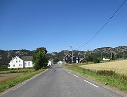
 View of the village | |
| Coordinates: 58°20′06″N 8°26′50″E / 58.3351°N 08.4472°E | |
| Country | Norway |
| Region | Southern Norway |
| County | Agder |
| District | Østre Agder |
| Municipality | Grimstad |
| Elevation | 7 m (23 ft) |
| Time zone | UTC+01:00 (CET) |
| • Summer (DST) | UTC+02:00 (CEST) |
| Post Code | 4886 Grimstad |
Reddal is a village in the municipality of Grimstad in Agder county, Norway. It is located in the western part of the municipality in the Landvik area, about 10 kilometres (6.2 mi) west of the town of Grimstad and about 5 kilometres (3.1 mi) southeast of the small village of Nygrenda. The main industry in the village is agriculture, with the most important products being potatoes, berries and grain. The large lake Syndle lies just north of the village.
The freshwater Reddalsvannet lake is located along the south side of the village area. There is a protected nature reserve at the lake. In order to gain additional farmland in Reddal, a canal was built in 1877 to lower the lake's water level by 4 metres (13 ft). This lowered the water down to sea level. The Reddal Canal (Norwegian: Reddalskanalen) connects the Reddalsvannet lake and the nearby Landviksvannet lake to the sea. Today, the canal is popular with small boats.[2]
References
- ^ "Reddal, Grimstad (Aust-Agder)". yr.no. Retrieved 16 November 2017.
- ^ Store norske leksikon. "Reddal" (in Norwegian). Retrieved 18 May 2010.


