
Puerto Rico Highway 6685
  Highway 6685 | ||||
|---|---|---|---|---|
| Ruta 6685 | ||||
| Route information | ||||
| Maintained by Puerto Rico DTPW | ||||
| Length | 11.9 km[1] (7.4 mi) | |||
| Major junctions | ||||
| South end | ||||
| ||||
| North end | ||||
| Location | ||||
| Country | United States | |||
| Territory | Puerto Rico | |||
| Municipalities | Ciales, Manatí | |||
| Highway system | ||||
| ||||
Puerto Rico Highway 6685 (PR-6685) is a rural highway in Puerto Rico that runs south to north, connecting the towns of Ciales and Manatí on Puerto Rico's north coast.[2] It runs slightly parallel to Puerto Rico Highway 149 until it ends at Puerto Rico Highway 2 in Manatí.[3] It has a junction with PR-149 in Ciales and with Puerto Rico Highway 642 in Río Arriba Saliente barrio, in Manatí.[4]
- Puerto Rico Highway 6685 by municipality
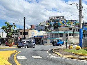 Northern terminus at PR-2 junction in downtown Manatí, looking south
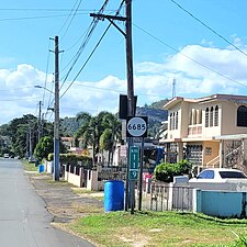 Heading north between Cordillera and Hato Viejo barrios in Ciales


Major intersections
 PR-2 east near the northern terminus of PR-6685 in downtown Manatí
 PR-6685 heading north to PR-2 at PR-642 intersection in Río Arriba Saliente, Manatí
 Signs for PR-6685 south and north at the western terminus of PR-643 in Río Arriba Saliente, Manatí


| Municipality | Location | km[1] | mi | Destinations | Notes |
|---|---|---|---|---|---|
| Ciales | Hato Viejo–Cordillera line | 11.9 | 7.4 | Southern terminus of PR-6685 | |
| Hato Viejo | 10.1 | 6.3 | |||
| 9.8– 9.7 | 6.1– 6.0 | Puente Mata de Plátano over the Río Grande de Manatí[5] | |||
| 8.8 | 5.5 | ||||
| Manatí | Río Arriba Saliente | 6.6 | 4.1 | ||
| 4.4 | 2.7 | ||||
| Manatí barrio-pueblo | 0.0 | 0.0 | Northern terminus of PR-6685 | ||
| 1.000 mi = 1.609 km; 1.000 km = 0.621 mi | |||||
See also
References
- ^ a b "PR-6685" (Map). Google Maps. Retrieved 28 February 2020.
- ^ "PR-6685, Ciales, Puerto Rico". geoview.info. Retrieved 28 February 2020.
- ^ "PR-6685, Manatí, Puerto Rico". geoview.info. Retrieved 28 February 2020.
- ^ National Geographic Maps (2011). Puerto Rico (Map). 1:125,000. Adventure Map (Book 3107). Evergreen, Colorado: National Geographic Maps. ISBN 978-1566955188. OCLC 756511572.
- ^ Luis F. Pumarada O’Neill (1991). "Los Puentes Históricos de Puerto Rico" (PDF) (in Spanish). pp. 99–100. Retrieved 10 March 2020.
External links
 Media related to Puerto Rico Highway 6685 at Wikimedia Commons