Ponts, Spain
Ponts | |
|---|---|
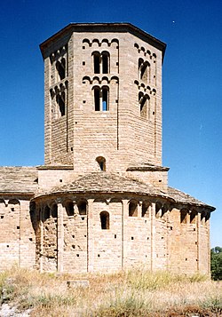
 Romanesque art in Sant Pere Church in Ponts | |
| Coordinates: 41°54′53.28″N 1°11′6.00″E / 41.9148000°N 1.1850000°E | |
| Country | |
| Autonomous Community | |
| Province | Lleida |
| Comarca | Noguera |
| Government | |
| • Mayor | Francisco Garcia Cañadas (2015)[1] |
| Area | |
• Total | 30.5 km2 (11.8 sq mi) |
| Elevation | 363 m (1,191 ft) |
| Population (2018)[3] | |
• Total | 2,604 |
| • Density | 85/km2 (220/sq mi) |
| Demonym | Pontsicans |
| Postal code | 25740 |
| Website | www |
Ponts (Catalan pronunciation: [ˈpɔns]) is a municipality and a town in the comarca of the Noguera in the province of Lleida, Catalonia, Spain. It is situated on the left bank of the Segre river near its confluence with the Llobregós river and at the point where the routes from Calaf (currently the C-1412 road) and Cervera (currently the L-313 road) meet the route from Lleida to La Seu d'Urgell (currently the C-1313 road).
Economy is based on agriculture (cereals, olives, vine, potato, sunflowers) and animal husbandry (domestic sheep, pigs, birds). The industry sector comprises food processing and textiles.
Main sights
- Sant Pere de Ponts, a Romanesque church built in the 11th century.
- Old quarter of Ponts. With the typical portico of the Major Street.
- Rialb reservoir. This is the biggest dam in Catalonia.
- Segarra-Garrigues Canal. It is the name of an important water line that supplies part of Lleida.
- Parc La Roca del Call. It is an outdoor multi-sports complex, especially canoeing and kayaking.
- Circuit del Bosquet (also known as Circuit de Ponts). It is one of the best motocross circuits in Catalonia.
- Boncompte Museum. It is a private collection of firearms.
References
- ^ "Ajuntament de Ponts". Generalitat of Catalonia. Retrieved 2015-11-13.
- ^ "El municipi en xifres: Ponts". Statistical Institute of Catalonia. Retrieved 2015-11-23.
- ^ Municipal Register of Spain 2018. National Statistics Institute.
- Panareda Clopés, Josep Maria; Rios Calvet, Jaume; Rabella Vives, Josep Maria (1989). Guia de Catalunya, Barcelona: Caixa de Catalunya. ISBN 84-87135-01-3 (Spanish). ISBN 84-87135-02-1 (Catalan).
External links
- Official website
- Government data pages (in Catalan)

