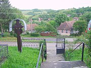
Gornești
Gornești Gernyeszeg | |
|---|---|
 Reformed church in Gornești | |
 Location in Mureș County | |
| Coordinates: 46°40′N 24°39′E / 46.667°N 24.650°E | |
| Country | Romania |
| County | Mureș |
| Government | |
| • Mayor (2020–2024) | Gyula Kolcsár[1] (UDMR) |
Area | 54.39 km2 (21.00 sq mi) |
| Elevation | 340 m (1,120 ft) |
| Population (2021-12-01)[2] | 5,072 |
| • Density | 93/km2 (240/sq mi) |
| Time zone | EET/EEST (UTC+2/+3) |
| Postal code | 547280 |
| Area code | (+40) 02 65 |
| Vehicle reg. | MS |
| Website | primariagornesti |
Gornești (formerly Ghernesig; Hungarian: Gernyeszeg, Hungarian pronunciation: [ˈɡɛrɲɛsɛɡ]) is a commune in Mureș County, Transylvania, Romania composed of nine villages:
- Gornești
- Iara de Mureș / Marosjára
- Ilioara / Kisillye
- Mura Mare / Nagyszederjes
- Mura Mică / Kisszederjes
- Pădureni / Erdőcsinád
- Periș / Körtvélyfája
- Petrilaca de Mureș / Magyarpéterlaka
- Teleac / Marostelek
Geography
Gornești lies on the Transylvanian Plateau, on the left bank of the Mureș River. Located in the central part of the county, it is crossed by national road DN15, which connects it to the county seat, Târgu Mureș, 19 km (12 mi) to the south, and to Reghin, 14 km (8.7 mi) to the north.
History
The commune formed part of the Székely Land region of the historical Transylvania province. Until 1918, it belonged to the Maros-Torda County of the Kingdom of Hungary. After the Hungarian–Romanian War of 1919 and the Treaty of Trianon of 1920, it became part of Romania.
Demographics
Gornești has an absolute Hungarian majority. According to the 2011 census, it has a population of 5,577, of which 71.9% are Hungarian; 18.5% are Romanian, and 9.5% Roma.[3]
Natives
- István Bethlen (1874–1946), aristocrat and statesman, Prime Minister of Hungary from 1921 to 1931
- Sámuel Teleki (1739–1822), Chancellor of Transylvania, famous book collector
- Alexandru Todea (1912–2002), Greek-Catholic bishop of the Alba Iulia Diocese and later cardinal
Economy
The Teleac gas field is located on the territory of the commune; it was discovered in 1915 and began production in 1930.
See also
References
- ^ "Results of the 2020 local elections". Central Electoral Bureau. Retrieved 11 June 2021.
- ^ "Populaţia rezidentă după grupa de vârstă, pe județe și municipii, orașe, comune, la 1 decembrie 2021" (XLS). National Institute of Statistics.
- ^ (in Romanian) Populația stabilă după etnie – județe, municipii, orașe, comune Archived 2016-01-18 at the Wayback Machine, National Institute of Statistics; accessed August 26, 2015


