Palestro
Palestro | |
|---|---|
| Comune di Palestro | |
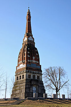
 Monument to the victims of the Battle of Palestro. | |
| Coordinates: 45°18′N 8°32′E / 45.300°N 8.533°E | |
| Country | Italy |
| Region | Lombardy |
| Province | Pavia (PV) |
| Frazioni | Pizzarosto |
| Government | |
| • Mayor | Maria Grazia Grossi Tinti |
| Area | |
• Total | 18 km2 (7 sq mi) |
| Population (30 April 2010)[2] | |
• Total | 2,022 |
| • Density | 110/km2 (290/sq mi) |
| Demonym | Palestresi |
| Time zone | UTC+1 (CET) |
| • Summer (DST) | UTC+2 (CEST) |
| Postal code | 27030 |
| Dialing code | 0384 |
| Patron saint | San Martino di Tours |
| Saint day | 11 November |
| Website | Official website |
Palestro is a town and comune in the province of Pavia. It is located on the banks of the river Sesia.
History
Although located in area settled by Celts, Etruscans, Romans and Lombards, Palestro is mentioned for the first time in 999 AD, when it was given to the bishop of Vercelli by emperor Otto III. It was located in the Via Francigena and at the time it was a fortified borough. Later it was ruled by the Visconti of Milan (1335-1452), then by the Borromeo family and, from 1500, by Spain, which was ended by its acquisition by the Duchy of Savoy in 1614.
Palestro was the site of the Battle of Palestro of 30–31 May 1859, in the course of the Second Italian War of Independence
Twin towns
Palestro is twinned with:
 Montebello della Battaglia, Italy, since 1984
- ^ "Superficie di Comuni Province e Regioni italiane al 9 ottobre 2011". Italian National Institute of Statistics. Retrieved 16 March 2019.
- ^ "Popolazione Residente al 1° Gennaio 2018". Italian National Institute of Statistics. Retrieved 16 March 2019.


