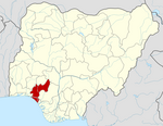
Ondo West
Ondo West | |
|---|---|
 | |
| Country | |
| State | Ondo State |
| Government | |
| • Body | Osemawe-in-Council |
| • Oba | Osemawe of Ondo Kingdom |
| Area | |
• Total | 370 sq mi (970 km2) |
| Population (2006) | |
• Total | 283,672 |
| Time zone | UTC+1 (WAT) |
 | |
Ondo West is a Local Government Area in Ondo State, Nigeria. Its headquarters are in the town of Ondo.[1]
It has an area of 970 km2 and a population of 283,672 at the 2006 census.
The postal code of the area is 351.[2]
There are four higher institutions in Ondo West: Adeyemi College of Education established in 1964 by the Federal Government of Nigeria and recently upgraded to a Federal University of Education; National Institute for Educational Planning and Administration (NIEPA) established in 1992 by the Federal Government; Wesley University established in 2008 by the Methodist Church, Nigeria; and the University of Medical Sciences, Ondo established by the Ondo State Government in 2015 to train medical and health professionals.
References
- ^ Nigeria, Media (2018-04-19). "List Of Towns And Villages In Ondo West L.G.A, Ondo State". Media Nigeria. Retrieved 2022-04-08.
- ^ "Post Offices- with map of LGA". NIPOST. Archived from the original on 2012-11-26. Retrieved 2009-10-20.

