North Aceh Regency
North Aceh Regency Kabupaten Aceh Utara | |
|---|---|
 Regent office of North Aceh in Lhoksukon | |
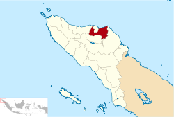
 Location within Aceh | |
| Coordinates: 5°00′N 96°45′E / 5.00°N 96.75°E | |
| Country | |
| Region | Sumatra |
| Province | |
| Established | 1956 |
| Regency seat | Lhoksukon |
| Government | |
| • Regent | Muhammad Thaib |
| • Vice Regent | Fauzi Yusuf |
| Area | |
• Total | 3,296.86 km2 (1,272.92 sq mi) |
| Population (mid 2023 estimate)[1] | |
• Total | 624,582 |
| • Density | 190/km2 (490/sq mi) |
| Time zone | UTC+7 (IWST) |
| Area code | (+62) 645 |
| Website | acehutara.go.id |
North Aceh Regency (Indonesian: Kabupaten Aceh Utara) is a regency in Indonesia's Aceh Province - which was formerly called the Aceh special territory (Daerah Istimewa Aceh) in 1959–2001), and then Nanggroë Aceh Darussalam in 2001–2009), before reverting to Aceh Province in 2009. It is located on the island of Sumatra. The regency covers an area of 3,296.86 square kilometres and had a population of 534,085 at the 2010 census[2] and 602,793 at the 2020 Census;[3] the official estimate as at mid 2023 was 624,582.[1]
The administrative centre is now at the town of Lhoksukon; this followed the splitting off of the western districts from the regency to form (by Law No. 48 of 1999) a separate Bireuen Regency on 4 October 1999, and then the creation (by Law No. 2 of 2001) of the independent city of Lhokseumawe out of what was formerly the capital, which was cut out of the regency on 21 June 2001.
Economy
This regency is included in one of the largest industrial regions outside Java, especially with the opening of liquid gas processing industry plants based on PT Arun LNG in Lhokseumawe, 1974. There were several large factories nearby at the time: PT.Kertas Kraft Aceh, pabrik Pupuk AAF (Aceh Asean Fertilizer) and pabrik Pupuk Iskandar Muda (PIM).[4] The Port of Krueng Geukueh is located in the regency.[5]
In the agricultural sector, the regency has a good reputation as an important rice producer. The whole North Aceh Regency has the greatest potential of any region in Aceh and its income per capita is above Rp 1.4 million (without oil and natural gas) or Rp 6 million (with oil and natural gas).[6]
Gas and petroleum fields were found in Lhokseumawe, North Aceh's former capital city around the 1970s. Then, many investors interested in its natural resources came to Aceh. Since then, liquefied natural gas (LNG) processed in refinery of PT. Arun Natural Gas Liquefaction (NGL) Co, coming from the installation of PT. ExxonMobil Oil Indonesia (EMOI) in Lhokseumawe industrial zone (now : Arun Lhokseumawe Special Economic Zone), had changed this regency to modern petrochemistry industrial region.[7]
There are 2 sectors dominating economical activity in North Aceh, i.e. mining and excavating, and processing industrial sector. In mining sector, the gas wells processed by PT. EMOI surely become one of this sector's pioneering factor.[8]
Religion
North Aceh's inhabitants are predominantly Muslim. Minorities still get the freedom to worship according to their respective religions.
Border
- North: Malacca Strait
- East: East Aceh Regency
- South: Central Aceh Regency
- West: Bireuen Regency
Administrative districts
The regency is divided administratively into twenty-seven districts (kecamatan), listed below with their areas and their populations at the 2010 Census[2] and the 2020 Census,[3] together with the official estimates as at mid 2023.[1] The table also includes the locations of the district administrative centres, the number of administrative villages (gampong) within each district, and its post code.
| Kode Wilayah |
Name of District (kecamatan) |
Area in km2 |
Pop'n Census 2010 |
Pop'n Census 2020 |
Pop'n Estimate mid 2023 |
Admin centre |
No. of villages |
Post code |
|---|---|---|---|---|---|---|---|---|
| 11.08.15 | Sawang [9] | 384.65 | 34,024 | 39,063 | 40,135 | Sawang | 39 | 24377 |
| 11.08.16 | Nisam [10] | 114.74 | 17,255 | 19,663 | 20,721 | Keude Amplah | 29 | 24378 |
| 11.08.27 | Nisam Antara[11] | 84.38 | 12,195 | 13,465 | 13,967 | Alue Dua | 6 | 24379 |
| 11.08.26 | Banda Baro [12] | 42.35 | 7,437 | 7,926 | 8,410 | Ulee Nyeue | 9 | 24376 |
| 11.08.03 | Kuta Makmur [13] | 151.32 | 22,208 | 26,379 | 28,307 | Buloh Blang Awa | 39 | 24371 |
| 11.08.22 | Simpang Keramat [14] | 79.78 | 8,781 | 9,957 | 10,994 | Kedee Simpang Empat | 16 | 24313 |
| 11.08.11 | Syamtalira Bayu [15] | 77.53 | 19,110 | 22,393 | 22,941 | Baru | 38 | 24370 |
| 11.08.25 | Geureudong Pase [16] | 269.28 | 4,484 | 5,534 | 5,924 | Mbang | 11 | 24373 |
| 11.08.07 | Meurah Mulia [17] | 202.57 | 17,756 | 21,024 | 22,304 | Jungka Gajah | 50 | 24372 |
| 11.08.05 | Matangkuli [18] | 56.94 | 16,558 | 18,756 | 19,621 | Matang Kuli | 49 | 24386 |
| 11.08.20 | Paya Bakong [19] | 418.32 | 12,794 | 15,555 | 15,937 | Keude Paya Bakong | 39 | 24383 |
| 11.08.24 | Pirak Timu [20] | 67.70 | 7,474 | 8,799 | 9,074 | Alue Bungkoh | 23 | 24384 |
| 11.08.17 | Cot Girek[21] | 189.00 | 18,492 | 20,305 | 20,537 | Cot Girek | 24 | 24352 |
| 11.08.14 | Tanah Jambo Aye [22] | 162.98 | 39,461 | 44,222 | 44,929 | Panton Labu | 47 | 24395 |
| 11.08.18 | Langkahan [23] | 150.52 | 21,090 | 22,518 | 23,192 | Langkahan | 23 | 24394 |
| 11.08.09 | Seunuddon [24] | 100.63 | 23,457 | 25,982 | 26,430 | Seunuddon | 33 | 24393 |
| 11.08.01 | Baktiya [25] | 158.67 | 32,731 | 37,657 | 39,463 | Alue Le Puteh | 57 | 24392 |
| 11.08.19 | Baktiya Barat [26] (West Baktiya) |
83.08 | 17,082 | 18,980 | 19,881 | Keude Sampoiniet | 26 | 24396 |
| 11.08.04 | Lhoksukon[27] | 243.00 | 44,358 | 49,733 | 51,421 | Lhoksukon | 75 | 24382 |
| 11.08.12 | Tanah Luas [28] | 30.64 | 22,217 | 25,193 | 26,380 | Blang Jruen | 57 | 24387 |
| 11.08.21 | Nibong [29] | 44.91 | 9,121 | 10,778 | 11,279 | Keude Nibong | 20 | 24385 |
| 11.08.08 | Samudera [30] | 43.28 | 24,589 | 27,147 | 28,366 | Geudong | 40 | 24374 |
| 11.08.10 | Syamtalira Aron [31] | 28.13 | 16,591 | 19,345 | 19,910 | Simpang Muling | 34 | 24381 |
| 11.08.13 | Tanah Pasir [32] | 20.38 | 8,445 | 9,978 | 10,136 | Jrat Manyang | 18 | 24390 |
| 11.08.23 | Lapang [33] | 19.27 | 7,974 | 8,806 | 8,862 | Lapang | 11 | 24391 |
| 11.08.06 | Muara Batu [34] | 33.34 | 24,585 | 27,753 | 28,588 | Krueng Mane | 24 | 24355 |
| 11.08.02 | Dewantara [35] | 39.47 | 43,797 | 45,882 | 46,873 | Krueng Geukueh | 15 | 24354 |
| Totals | 3,296.86 | 534,085 | 602,793 | 624,582 | Lhoksukon | 852 |
Politics
The current regent is Muhammad Thaib also known as Cek Mad.
References
- ^ a b c Badan Pusat Statistik, Jakarta, 28 February 2024, Kabupaten Aceh Utara Dalam Angka 2024 (Katalog-BPS 1102001.1108)
- ^ a b Biro Pusat Statistik, Jakarta, 2011.
- ^ a b Badan Pusat Statistik, Jakarta, 2021.
- ^ ADLI, WR HAMZATIL (2014). "FAKTOR-FAKTOR YANG MEMPENGARUHI PERTUMBUHAN EKONOMI KABUPATEN ACEH UTARA". onesearch.id. Archived from the original on 2023-09-15. Retrieved 2020-01-08.
- ^ "Krueng Geukueh Bisa Impor". Serambi Indonesia (in Indonesian). 18 October 2013. Archived from the original on 8 August 2021. Retrieved 8 August 2021.
- ^ Martahadi, Martahadi (2018-08-18). "Perubahan Struktur Ekonomi Kabupaten Aceh Utara, Kabupaten Bireuen dan Kota Lhokseumawe". Jurnal Serambi Ekonomi Dan Bisnis. 1 (1): 11–18. ISSN 2354-970X. Archived from the original on 2022-03-31. Retrieved 2020-01-08.
- ^ Mauliza, Nur; Andriyani, Devi (2018-04-01). "Pengaruh Tingkat Pengangguran Dan Pengeluaran Pemerintah Terhadap Pertumbuhan Ekonomi di Kabupaten Aceh Utara Tahun 2007-2016". Jurnal Ekonomi Regional Unimal. 1 (1): 8–14. doi:10.29103/jeru.v1i1.981. ISSN 2615-126X. S2CID 203542556. Archived from the original on 2020-07-19. Retrieved 2020-01-08.
- ^ Aceh Utara Dalam Angka 2005 (in Indonesian). KabupatenKota.Com. ISBN 978-602-00-0010-7. Archived from the original on 2023-09-15. Retrieved 2020-11-18.
- ^ Badan Pusat Statistik, Jakarta, 26 September 2024, Kecamatan Sawang Dalam Angka 2024 (Katalog-BPS 1102001.1111010
- ^ Badan Pusat Statistik, Jakarta, 26 September 2024, Kecamatan Nisam Dalam Angka 2024 (Katalog-BPS 1102001.1111020
- ^ Badan Pusat Statistik, Jakarta, 26 September 2024, Kecamatan Nusam Antara Dalam Angka 2024 (Katalog-BPS 1102001.1111021
- ^ Badan Pusat Statistik, Jakarta, 26 September 2024, Kecamatan Banda Baro Dalam Angka 2024 (Katalog-BPS 1102001.1111022
- ^ Badan Pusat Statistik, Jakarta, 26 September 2024, Kecamatan Kura Makmur Dalam Angka 2024 (Katalog-BPS 1102001.1111030
- ^ Badan Pusat Statistik, Jakarta, 26 September 2024, Kecamatan Simpang Keramat Dalam Angka 2024 (Katalog-BPS 1102001.1111031
- ^ Badan Pusat Statistik, Jakarta, 26 September 2024, Kecamatan Syamtalira Bayu Dalam Angka 2024 (Katalog-BPS 1102001.1111040
- ^ Badan Pusat Statistik, Jakarta, 26 September 2024, Kecamatan Geureudong Pase Dalam Angka 2024 (Katalog-BPS 1102001.1111041
- ^ Badan Pusat Statistik, Jakarta, 26 September 2024, Kecamatan Meurah Mulia Dalam Angka 2024 (Katalog-BPS 1102001.1111050
- ^ Badan Pusat Statistik, Jakarta, 26 September 2024, Kecamatan Matangkuli Dalam Angka 2024 (Katalog-BPS 1102001.1111060
- ^ Badan Pusat Statistik, Jakarta, 26 September 2024, Kecamatan Paya Bakong Dalam Angka 2024 (Katalog-BPS 1102001.1111061
- ^ Badan Pusat Statistik, Jakarta, 26 September 2024, Kecamatan Pirak Timu Dalam Angka 2024 (Katalog-BPS 1102001.1111062
- ^ Badan Pusat Statistik, Jakarta, 26 September 2024, Kecamatan Cot Girek Dalam Angka 2024 (Katalog-BPS 1102001.1111070
- ^ Badan Pusat Statistik, Jakarta, 26 September 2024, Kecamatan Tanah Jambo Aye Dalam Angka 2024 (Katalog-BPS 1102001.1111080
- ^ Badan Pusat Statistik, Jakarta, 26 September 2024, Kecamatan Langkahan Dalam Angka 2024 (Katalog-BPS 1102001.1111081
- ^ Badan Pusat Statistik, Jakarta, 26 September 2024, Kecamatan Seunuddon Dalam Angka 2024 (Katalog-BPS 1102001.1111090
- ^ Badan Pusat Statistik, Jakarta, 26 September 2024, Kecamatan Baktiya Angka 2024 (Katalog-BPS 1102001.1111100
- ^ Badan Pusat Statistik, Jakarta, 26 September 2024, Kecamatan Baktiya Barat Dalam Angka 2024 (Katalog-BPS 1102001.1111101
- ^ Badan Pusat Statistik, Jakarta, 26 September 2024, Kecamatan Lhoksukon Dalam Angka 2024 (Katalog-BPS 1102001.1111110
- ^ Badan Pusat Statistik, Jakarta, 26 September 2024, Kecamatan Tanah Luas Dalam Angka 2024 (Katalog-BPS 1102001.1111120
- ^ Badan Pusat Statistik, Jakarta, 26 September 2024, Kecamatan Nibong Dalam Angka 2024 (Katalog-BPS 1102001.1111121
- ^ Badan Pusat Statistik, Jakarta, 26 September 2024, Kecamatan Samudera Dalam Angka 2024 (Katalog-BPS 1102001.1111130
- ^ Badan Pusat Statistik, Jakarta, 26 September 2024, Kecamatan Syamtalira Aron Dalam Angka 2024 (Katalog-BPS 1102001.1111140
- ^ Badan Pusat Statistik, Jakarta, 26 September 2024, Kecamatan Tanah Pasir Dalam Angka 2024 (Katalog-BPS 1102001.1111150
- ^ Badan Pusat Statistik, Jakarta, 26 September 2024, Kecamatan Lapang Dalam Angka 2024 (Katalog-BPS 1102001.1111151
- ^ Badan Pusat Statistik, Jakarta, 26 September 2024, Kecamatan Muara Batu Dalam Angka 2024 (Katalog-BPS 1102001.1111160
- ^ Badan Pusat Statistik, Jakarta, 26 September 2024, Kecamatan Dewantara Dalam Angka 2024 (Katalog-BPS 1102001.1111170
External links
- (in Indonesian) Official website


