Nilphamari Sadar Upazila
Nilphamari Sadar নীলফামারী সদর | |
|---|---|
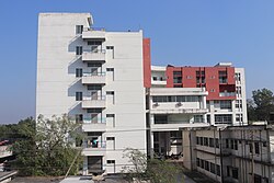
 Hospital in Nilphamari | |
 | |
| Coordinates: 25°56.5′N 88°50.7′E / 25.9417°N 88.8450°E | |
| Country | |
| Division | Rangpur |
| District | Nilphamari |
| Headquarters | Nilphamari |
| Area | |
• Upazila | 373.30 km2 (144.13 sq mi) |
| • Metro | 19.28 km2 (7.44 sq mi) |
| Population | |
• Upazila | 523,966 |
| • Density | 1,400/km2 (3,600/sq mi) |
| Time zone | UTC+6 (BST) |
| Postal code | 5300[2] |
| Area code | 0551[3] |
| Website | nilphamarisadar |
Nilphamari Sadar (Bengali: নীলফামারী সদর) is an upazila of Nilphamari District in the Division of Rangpur, Bangladesh.[4] Nilphamari Sadar thana was established in 1870. It was under Daroani thana before 1870. It gradually turned into an Upazilla in 1984.
Geography
Nilphamari Sadar is located at 25°56′30″N 88°50′40″E / 25.9417°N 88.8444°E. It has 97,088 households and total area 373.30 km2. It is bounded by Debiganj and Domar upazilas on the north, Jaldhaka and Kishoreganj upazilas on the east, Saidpur Upazila to the south and Khansama Upazila to the west.[4]
Demographics
According to the 2011 Census of Bangladesh, Nilphamari Sadar Upazila had 97,088 households and a population of 435,162. 107,932 (24.80%) were under 10 years of age. Nilphamari Sadar had a literacy rate (age 7 and over) of 45.73%, compared to the national average of 51.8%, and a sex ratio of 986 females per 1000 males. 45,386 (10.43%) lived in urban areas.[6][7]
As of the 1991 Bangladesh census, Nilphamari Sadar has a population of 306051. Males constitute 51.23% of the population, and females 48.77%. This Upazila's eighteen up population is 150237. Nilphamari Sadar has an average literacy rate of 23.2% (7+ years), and the national average of 32.4% literate.[8]
Administration
Nilphamari Thana was formed in 1870 and it was turned into an upazila in 1984.[9]
Nilphamari Sadar Upazila is divided into Nilphamari Municipality and 15 union parishads: Chaora Bargachaup, Chaprasarnjami, Charaikhola, Gorgram, Itakhola, Kachukata, Khoksabari, Kundapukur, Lakshmichap, Palasbari, Ramnagar, Songalsi, Sonaray, and Tupamari. The union parishads are subdivided into 109 mauzas and 108 villages.[6]
At present, Nilphamari Municipality has an area of 27.50 sqkm and is subdivided into 15 wards. The processing of increasing the area of Nilphamari Municipality is ongoing. The proposed area will be 42.70 sqkm.[6]
Education
According to Banglapedia, Nilphamari Government High School, founded in 1882, is a notable secondary school.[4]
See also
References
- ^ National Report (PDF). Population and Housing Census 2022. Vol. 1. Dhaka: Bangladesh Bureau of Statistics. November 2023. p. 403. ISBN 978-9844752016.
- ^ "Bangladesh Postal Code". Dhaka: Bangladesh Postal Department under the Department of Posts and Telecommunications of the Ministry of Posts, Telecommunications and Information Technology of the People's Republic of Bangladesh. 21 October 2024.
- ^ "Bangladesh Area Code". China: Chahaoba.com. 18 October 2024.
- ^ a b c Sattar, Abdus (2012). "Nilphamari Sadar Upazila". In Islam, Sirajul; Jamal, Ahmed A. (eds.). Banglapedia: National Encyclopedia of Bangladesh (Second ed.). Asiatic Society of Bangladesh.
- ^ Population and Housing Census 2022 - District Report: Nilphamari (PDF). District Series. Dhaka: Bangladesh Bureau of Statistics. June 2024. ISBN 978-984-475-285-6.
- ^ a b c "Bangladesh Population and Housing Census 2011 Zila Report – Nilphamari" (PDF). bbs.gov.bd. Bangladesh Bureau of Statistics.
- ^ "Community Tables: Nilphamari district" (PDF). bbs.gov.bd. Bangladesh Bureau of Statistics. 2011.
- ^ "Population Census Wing, BBS". Archived from the original on 2005-03-27. Retrieved November 10, 2006.
- ^ "Nilphamari Sadar Upazila - Banglapedia". en.banglapedia.org. Retrieved 2023-02-21.

