Neiafu (Vavaʻu)
Neiafu | |
|---|---|
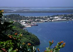
 Port of Refuge viewed from Mt. Talau | |
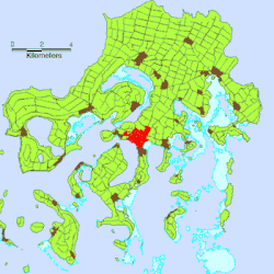
 Location of Neiafu on Vavaʻu Island | |
| Coordinates: 18°39′03″S 173°58′59″W / 18.65083°S 173.98306°W | |
| Country | |
| Island | Vavaʻu |
| Population (2021) | |
• Total | 3,845 |
| Time zone | UTC+13 (–) |
| Climate | Af |
Neiafu is the second-largest town in Tonga with a population of 3,845 in 2021.[1] It is situated beside the Port of Refuge, a deep-water harbour on the south coast of Vavaʻu, the main island of the Vavaʻu archipelago in northern Tonga. To the north-west lies the 131-metre high (430 ft) Mt. Talau with its distinctive flat top.
Neiafu is the administrative centre of the Vavaʻu group and has government offices, banks, schools, a police station and a hospital. It is also an important centre for tourism with many yachts anchoring in the Port of Refuge.
In the late 19th century Neiafu was the location of a German coaling-station, established under the country's 1876 Treaty of Friendship with Tonga.[2] The base was transferred to Britain in 1900 with the establishment of a British protectorate.[3]
The town is powered by a 300kW solar PV farm with battery backup in the hamlet of Kāmeli.[4]
References
- ^ "PRELIMINARY RESULT TONGA POPULATION CENSUS 2021" (PDF). Tonga Statistics Department. 24 December 2021. p. 5. Retrieved 31 December 2021.
- ^ Basil C. Thomson (1984). "XIII — Vavau". Savage Island: An Account of a Sojourn in Niue and Tonga. Papakura: R. McMillan. p. 186-187. Retrieved 17 December 2022 – via NZETC.
- ^ Basil C. Thomson (1984). "XII — The King and His Ministers". Savage Island: An Account of a Sojourn in Niue and Tonga. Papakura: R. McMillan. p. 172-173. Retrieved 17 December 2022 – via NZETC.
- ^ "New solar plant and battery energy storage system for Vava'u". Matangi Tonga. 14 March 2023. Retrieved 15 March 2023.
External links

