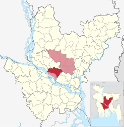
Nawabganj Upazila, Dhaka
Nawabganj | |
|---|---|
 Bhanga Masjid | |
 | |
| Coordinates: 23°40′00″N 90°10′00″E / 23.6667°N 90.1667°E | |
| Country | |
| Division | Dhaka |
| District | Dhaka |
| Area | |
• Total | 244.80 km2 (94.52 sq mi) |
| Population | |
• Total | 348,807 |
| • Density | 1,400/km2 (3,700/sq mi) |
| Time zone | UTC+6 (BST) |
| Postal code | 1320[2] |
| Area code | 06225[3] |
| Website | website of Nawabganj |
Nawabganj (Bengali: নবাবগঞ্জ) is an upazila of Dhaka District in the Dhaka Division, Bangladesh.[4]
Geography
Nawabganj is located at 23°40′00″N 90°10′00″E / 23.6667°N 90.1667°E. It has 70,757 households and a total area 244.80 km2.
Nawabganj is surrounded by Singair Upazila on the North, Dohar Upazila on the South, Keraniganj, Sirajdikhan and Sreenagar Upazilas on the East, Harirampur and Manikganj Sadar Upazilas on the West.
Demographics
According to the 2011 Census of Bangladesh, Nawabganj Upazila had 70,757 households and a population of 318,811. 66,367 (20.82%) were under 10 years of age. Nawabganj had a literacy rate (age 7 and over) of 57.8%, compared to the national average of 51.8%, and a sex ratio of 1135 females per 1000 males. 16,917 (5.31%) lived in urban areas.[5][6]
As of the 1991 Bangladesh census, Nawabganj had a population of 269,189. Males constituted 49.31% of the population, and females 50.69%. 134,813 residents were over eighteen. Nawabganj had an average literacy rate of 34.5% (7+ years). For reference, the national average is 32.4%.[7]
Politics
Nawabganj Upazila is currently under rule of the Bangladesh Awami League. From the 2008 elections, it merged with Dohar Upazila as Dhaka-1. BEXIMCO Group Chairman Md Salman Fazlur Rahman is the current Member of Parliament, representing Dhaka-1.
Nawabganj Thana, now an Upazila, was established in 1974.
Political parties
Many political parties are currently active in Nawabganj. The most popular parties include Bangladesh Awami League, which runs as Nawabganj Upazila Awami League and the Bangladesh Nationalist Party, which runs as Nawabganj Upazila BNP and the Jatiyo Party, which runs as Nawabganj Upazila Jatiyo Party
Politicians
- A big number of politicians come from Nawabganj. The notable are:
- Salman F Rahman
- Abdul Mannan Bhuiyan
- Moslem Uddin Khan
- Abdul Haleem Chowdhury
- Borhanuddin Khan
- Khandaker Abu Ashfaq
- Salma Islam
- Abdul Baten Mia
- Poniruzzaman Torun
- Muazzam Hossain
- Azizur Rahman Foku
Administration
Nawabganj Upazila is divided into 14 union parishads: Agla, Bakshanagar, Bandura, Barrah, Baruakhali, Churain, Galimpur, Jantrail, Joykrishnapur, Kailail, Kalakopa, Nayansree, Shekaripara, and Sholla. The Union parishads are subdivided into 190 mauzas and 342 villages.[8]
See also
References
- ^ a b Population and Housing Census 2022 - District Report: Dhaka (PDF). District Series. Dhaka: Bangladesh Bureau of Statistics. June 2024. pp. xiv, 54. ISBN 978-984-475-286-3.
- ^ "Bangladesh Postal Code". Dhaka: Bangladesh Postal Department under the Department of Posts and Telecommunications of the Ministry of Posts, Telecommunications and Information Technology of the People's Republic of Bangladesh. 19 October 2024.
- ^ "Bangladesh Area Code". Stockholm, Sweden: Rebtel.com. 18 October 2024.
- ^ Md. Abu Hasan Farooque (2012). "Nawabganj Upazila (Dhaka District)". In Sirajul Islam and Ahmed A. Jamal (ed.). Banglapedia: National Encyclopedia of Bangladesh (Second ed.). Asiatic Society of Bangladesh.
- ^ "Bangladesh Population and Housing Census 2011 Zila Report – Dhaka" (PDF). bbs.gov.bd. Bangladesh Bureau of Statistics.
- ^ "Community Tables: Dhaka district" (PDF). bbs.gov.bd. 2011.
- ^ "Population Census Wing, BBS". Archived from the original on 2005-03-27. Retrieved November 10, 2006.
- ^ "District Statistics 2011: Dhaka" (PDF). Bangladesh Bureau of Statistics. Archived from the original (PDF) on 24 April 2015. Retrieved 14 July 2014.

