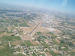
Nampa Municipal Airport
Nampa Municipal Airport | |||||||||||
|---|---|---|---|---|---|---|---|---|---|---|---|
 Aerial view, 2007 | |||||||||||
| Summary | |||||||||||
| Airport type | Public | ||||||||||
| Owner | City of Nampa | ||||||||||
| Serves | Nampa, Idaho | ||||||||||
| Elevation AMSL | 2,537 ft / 773 m | ||||||||||
| Coordinates | 43°34′53″N 116°31′23″W / 43.58139°N 116.52306°W | ||||||||||
| Website | www.NampaAirport.org | ||||||||||
| Map | |||||||||||
 | |||||||||||
| Runways | |||||||||||
| |||||||||||
| Statistics (2007) | |||||||||||
| |||||||||||
Nampa Municipal Airport (ICAO: KMAN, FAA LID: MAN, formerly S67) is a city-owned public airport in Nampa, in Canyon County, Idaho.[2] The FAA's National Plan of Integrated Airport Systems for 2009–2013 called it a general aviation airport.[3]
It is used for private, emergency, military and industrial aviation and is home to the Warhawk Air Museum. The airport has ongoing hangar construction. The Civil Air Patrol Nampa Squadron is on airport grounds co-located with EAA in the Shep-Rock hangar. Nampa Municipal Airport is a member of Rocky Mountain Air and the Snake River Flight Training Club. Mission Aviation Fellowship is also headquartered at the Nampa Airport.
Most U.S. airports use the same three-letter location identifier for the FAA and IATA, but this airport is assigned MAN by the FAA and has no designation from the IATA[4] (which assigned MAN to Manchester Airport in Manchester, England, United Kingdom).[5]
Facilities and aircraft
Nampa Municipal Airport covers 126 acres (51 ha) at an elevation of 2,537 feet (773 m) above mean sea level. It has one asphalt runway, 11/29, 5,000 by 75 feet (1,524 x 23 m).[2]
In the year ending June 20, 2007 the airport had 105,600 aircraft operations, average 289 per day: 98.5% general aviation and 1.5% air taxi. 277 aircraft were then based at this airport: 86.6% single-engine, 2.9% multi-engine, 2.5% helicopter, 4% glider and 4% ultralight.[2]
Services
Services are for pilots only. Some services include cheap aircraft stowing, pilot service (such as a lounge, internet access, and rentals), and transportation. The airport also offers full service during business hours. Upstairs in the Ops building is the Tower Grill. The restaurant is open to the public.[6]
See also
References
- ^ Nampa Municipal Airport, official site
- ^ a b c d FAA Airport Form 5010 for MAN PDF. Federal Aviation Administration. Effective 3 June 2010.
- ^ National Plan of Integrated Airport Systems for 2009–2013: Appendix A: Part 2 (PDF, 1.04 MB). Federal Aviation Administration. Updated 15 October 2008.
- ^ "Nampa Municipal Airport (ICAO: KMAN, FAA: MAN)". Great Circle Mapper. Retrieved 16 June 2010.
- ^ "Manchester, England, United Kingdom (IATA: MAN, ICAO: EGCC)". Great Circle Mapper. Retrieved 16 June 2010.
- ^ "Home". thetowergrill.com.
External links
- Nampa Municipal Airport page at City of Nampa website
- Nampa Municipal Airport at Idaho Transportation Department
- Aerial image as of 25 May 1992 from USGS The National Map
- Warhawk Air Museum
- Resources for this airport:
- FAA airport information for MAN
- AirNav airport information for KMAN
- FlightAware airport information and live flight tracker
- NOAA/NWS weather observations: current, past three days
- SkyVector aeronautical chart, Terminal Procedures
