Kitanada Station
S11 Kitanada Station 喜多灘駅 | |||||||||||
|---|---|---|---|---|---|---|---|---|---|---|---|
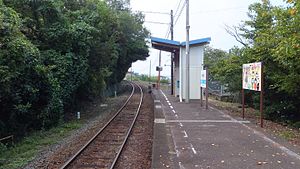
 Kitanada Station in 2015 | |||||||||||
| General information | |||||||||||
| Location | Nagahamacho Konbo, Ōzu City, Ehime Prefecture 799-3411 Japan | ||||||||||
| Coordinates | 33°38′15″N 132°31′52″E / 33.6374°N 132.5311°E | ||||||||||
| Operated by | |||||||||||
| Line(s) | Yosan Line | ||||||||||
| Distance | 228.2 km (141.8 mi) from Takamatsu | ||||||||||
| Platforms | 1 side platform | ||||||||||
| Tracks | 1 | ||||||||||
| Construction | |||||||||||
| Structure type | At grade (sidehill cutting) | ||||||||||
| Other information | |||||||||||
| Status | Unstaffed | ||||||||||
| Station code | S11 | ||||||||||
| History | |||||||||||
| Opened | 6 October 1935 | ||||||||||
| Passengers | |||||||||||
| FY2019 | 30 | ||||||||||
| Services | |||||||||||
| |||||||||||
| |||||||||||
Kitanada Station (喜多灘駅, Kitanada-eki) is a passenger railway station in the city of Ōzu, Ehime Prefecture, Japan. It is operated by JR Shikoku and has the station number "S11".[1][2]
Lines
Kitanada Station is located on the older, original, branch of the Yosan Line which runs along the coast from Mukaibara to Iyo-Ōzu and is 228.2 km from the beginning of the line at Takamatsu.[3] Only local trains stop at the station. Eastbouund local services end at Matsuyama. Connections with other services are needed to travel further east of Matsuyama on the line.[4]
Layout
The station consists of a side platform serving a single track on a sidehill cut. There is no station building, only a shelter for waiting passengers. A steep flight of steps leads up to the station from the main road. A toilet building is located at the base of the steps and there is limited parking.[2][5] A siding branches off the track and leads to a disused freight platform. There are also traces of trackbed on the other side of the passenger platform, indicating that it was once an island serving two tracks.[3]
- A view of the station entrance.
History
The station was opened on 6 October 1935 as an intermediate stop when the then Yosan mainline was extended from Shimonada to Iyo-Nagahama, thus linking up with the track of the then Ehime Line and establishing through traffic from Takamatsu to Iyo-Ōzu. At that time the station was operated by Japanese Government Railways (JGR), later becoming Japanese National Railways (JNR). With the privatization of JNR on 1 April 1987, the station came under the control of JR Shikoku.[6][7]
Surrounding area
This station is on the border of Iyo and Ozu cities, and the city border runs through the middle of the platform. The sea can be clearly seen from the platform, and the coast can be reached just by walking for a few minutes from the station.
See also
References
- ^ "Shikoku Railway Route Map" (PDF). JR Shikoku. Retrieved 27 December 2017.
- ^ a b "喜多灘" [Kitanada]. hacchi-no-he.net. Retrieved 14 January 2018.
- ^ a b Kawashima, Ryōzō (2013). 図説: 日本の鉄道 四国・九州ライン 全線・全駅・全配線・第2巻 四国西部エリア [Japan Railways Illustrated. Shikoku and Kyushu. All lines, all stations, all track layouts. Volume 2 Western Shikoku] (in Japanese). Kodansha. pp. 29, 73. ISBN 9784062951616.
- ^ "Kitanada Station Timetable" (PDF). JR Shikoku. Retrieved 14 January 2018.
- ^ "喜多灘駅" [Kitanada Station]. shikoku.org.uk. Retrieved 14 January 2018.
- ^ Ishino, Tetsu; et al., eds. (1998). 停車場変遷大事典 国鉄・JR編 [Station Transition Directory – JNR/JR] (in Japanese). Vol. II. Tokyo: JTB Corporation. p. 639. ISBN 4-533-02980-9.
- ^ Ishino, Tetsu; et al., eds. (1998). 停車場変遷大事典 国鉄・JR編 [Station Transition Directory – JNR/JR] (in Japanese). Vol. I. Tokyo: JTB Corporation. pp. 213–215. ISBN 4-533-02980-9.
External links
![]() Media related to Kitanada Station at Wikimedia Commons
Media related to Kitanada Station at Wikimedia Commons


