Kinburn Peninsula
Kinburn Peninsula | |
|---|---|
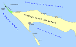
 A map of Kinburn Peninsula | |
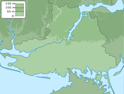
| Coordinates: 46°30′27″N 31°46′44″E / 46.50750°N 31.77889°E | |
| Location | Pokrovka, Pokrovske, Vasylivka (Mykolaiv Oblast) and Heroiske (Kherson Oblast), Ukraine |
| Part of |  |
| Dimensions | |
| • Length | 40 kilometres (25 mi)[1] |
| • Width | 10 kilometres (6.2 mi) |
The Kinburn Peninsula (Ukrainian: Кінбурнський півострів, romanized: Kinburnskyi pivostriv, Russian: Кинбурнский полуостров, romanized: Kinburnskiy poluostrov, Turkish: Kılburun) is a peninsula in Southern Ukraine, which separates the Dnieper–Bug estuary from the Black Sea. Administratively the peninsula is divided between two regions: Mykolaiv Oblast and Kherson Oblast, population 1,450. It is part of the Ivory Coast of Sviatoslav National Nature Park. Since April 2022, the Kinburn Peninsula has been fully occupied by Russian forces.
Etymology
Etymology comes from Turkish Kılburun, literally 'nose (land strip) [as subtle as a] hair'.[2]
Geography
The western tip of the peninsula extends into the Kinburn Spit.
To the south is a pair of islands, Dovhyi and Kruhlyi - both belong administratively to the Mykolaiv Raion of Mykolaiv Oblast.[3]
The peninsula includes the villages of Pokrovka, Pokrovske and Vasylivka, in Mykolaiv Oblast, and Heroiske, in the Kherson Oblast.
History
The Battle of Kinburn was fought on 12 October (N.S.)/1 October (O.S.) 1787 as part of the Russo-Turkish War (1787–1792).
The Battle of Kinburn was fought on 17 October 1855 as part of the Crimean War.
2022 Russian invasion
References
- ^ Land of Achilles and Prince Svyatoslav. Svyatoslav's White Coast National Park website, nationalparkbilosvyat.org.ua.
- ^ "Ḳi̇lburun". referenceworks.brillonline.com. 24 April 2012.
- ^ Black Sea islands of Mykolaiv Oblast archived from www.library.vn.ua


