Kelvingrove, Glasgow
| Kelvingrove | |
|---|---|
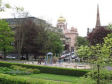
 Converted church on Derby Street | |
Location within Glasgow | |
| OS grid reference | NS571660 |
| Council area | |
| Lieutenancy area |
|
| Country | Scotland |
| Sovereign state | United Kingdom |
| Post town | GLASGOW |
| Postcode district | G3 7 |
| Dialling code | 0141 |
| Police | Scotland |
| Fire | Scottish |
| Ambulance | Scottish |
| UK Parliament | |
| Scottish Parliament | |
Kelvingrove is a neighbourhood in the city of Glasgow, Scotland. It is situated north of the River Clyde in the West End of the city, and directly borders Kelvingrove Park to the north and the grounds of the Kelvingrove Art Gallery and Museum to the west. Its other boundaries are not precisely defined, but roughly correspond to Sauchiehall Street to the south opposite the Sandyford neighbourhood, and the Charing Cross area to the east.
Description

Along with Charing Cross and the Park District a short distance to the north, Kelvingrove forms part of the 'Park' conservation area,[1] one of 25 such zones covered by Glasgow City Council.[2] Many of its townhouses and tenements, dating from the mid to late 19th century,[3][4][5] are listed buildings.[6][7][8][9]
There were also church buildings closer to the park, one of which at North Claremont Street[10] was demolished in the 1960s and the site is now occupied by one of the few purpose-built office buildings in the area;[11] its congregation moved to the other local church at Derby Street, but that was converted into apartments in the late 1970s,[12][13][14] with the congregation being absorbed by Anderston Church.[15] The open area of grass and trees adjacent to the Derby Street building was once occupied by Kelvingrove UP Church, which was demolished after a fire in 1920.[16][17]

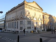
The nearby Queens's Rooms building at La Belle Place[18] also served as a Christian Science Church from the 1940s[19] before becoming a Hindu temple in 2006,[20][21][22] the largest such facility in Scotland. The building was designed in the 1850s by Charles Wilson who was also responsible for two adjacent blonde sandstone tenements featuring ornate carvings dating from the same time.[23]
Owing to its location between the tourist areas of Glasgow city centre, the West End (centred on Byres Road) and the entertainment venues at the SEC Centre, the neighbourhood has a large number of hotels among its tenements, most on the main thoroughfare, Sauchiehall Street adjoining Sandyford.[a] There are also several established restaurants[b] and bars,[37][38][39][40] a provision which increased markedly in the 2010s as the wider area (usually marketed as Finnieston) around Argyle Street became more popular as a destination in its own right.[41][42]
The sections of Kelvingrove Park closest to the residential area include a skatepark, two children's play areas and the Kelvingrove Lawn Bowls Centre which also features public-use tennis courts.
References
- ^ West End community fights back against plans to build on Conservation Area, Evening Times, 26 September 2018
- ^ Conservation areas in Glasgow, Glasgow City Council
- ^ City Views: Somerset Place, Sauchiehall Street (Glasgow University Library, Special Collections, Wylie Collection, Allan & Ferguson, 1843), The Glasgow Story
- ^ City Views: Royal Crescent, Glasgow (Glasgow University Library, Special Collections, Wylie Collection, Allan & Ferguson, 1843), The Glasgow Story
- ^ The Buildings of Scotland: Glasgow (page 290), Elizabeth Williamson, Anne Riches, Malcolm Higgs, 1990, ISBN 9780140710694
- ^ 1-24 (Inclusive Nos) Royal Crescent with 1 North Claremont Street and 36 Kelvingrove Street, British Listed Buildings
- ^ 1-20 (Inclusive Nos) Royal Terrace, 11b-19 (Odd Nos) North Claremont Street and 66 Kelvingrove Street, British Listed Buildings
- ^ 1055-1065 (Odd Nos) Sauchiehall Street, 23 Radnor Street, British Listed Buildings
- ^ 901, 903 Sauchiehall Street, British Listed Buildings
- ^ Kelvingrove Church, Kelvingrove, Glasgow West-end Addresses and their Occupants 1836-1915
- ^ Claremont UP Church (Glasgow University Library, Theology, 1875), The Glasgow Story
- ^ 49 Derby Street, 22, 30 Bentinck Street, British Listed Buildings
- ^ Glasgow, 20-30 Bentinck Street, Kelvingrove Parish Church, Canmore
- ^ Finnieston Church, Architecture Glasgow
- ^ Anderston Kelvingrove Parish Church gets noticed, Secret Scotland, 1 October 2018
- ^ 37 & 41 Kelvingrove Street, Kelvingrove, Glasgow West-end Addresses and their Occupants 1836-1915
- ^ Basic Site Details: Kelvingrove UP Church, Dictionary of Scottish Architects
- ^ 1 La Belle Place, Kelvingrove, Glasgow West-end Addresses and their Occupants 1836-1915
- ^ Glasgow, 1 La Belle Place, Christian Science Church, Canmore
- ^ Introduction, Hindu Mandir Glasgow
- ^ New Hindu temple opens in Glasgow, BBC News, 19 July 2006
- ^ Fire severely damages Hindu temple in Glasgow, BBC News, 30 May 2010
- ^ Charles Wilson (1810-63), Glasgow - City of Sculpture
- ^ Welcome, Kelvingrove Hotel
- ^ Welcome to the Sandyford Hotel, Sandyford Hotel Glasgow
- ^ Home, Argyll Hotel Glasgow
- ^ About Us, Lorne Hotel Glasgow
- ^ A very warm welcome, Acorn Hotel
- ^ Welcome to the Sandyford Lodge Hotel, The Sandyford Lodge
- ^ Welcome to the Devoncote Hotel, Devoncote Hotel
- ^ About Us, Mister Singh's India
- ^ Home, Ox and Finch
- ^ Experience the taste of India, Mother India
- ^ Home, The Butchershop Bar & Grill
- ^ Kelvingrove Restaurant, The Sisters Restaurant
- ^ Home, Kelvingrove Café
- ^ Bar Crawls: Glasgow - The Sauchiehall Street Saunter, The List, 18 November 2011
- ^ The Park Bar, The Skinny
- ^ Popular West End pub The Grove submits plans for makeover, Evening Times, 22 May 2019
- ^ CAMRA hits out at brewery plans for cult Finnieston pub, Campaign for Real Ale
- ^ Why Glasgow's Finnieston neighbourhood is now up there with London's Shoreditch, Evening Times, 23 November 2015
- ^ Is This Part of Glasgow Really 'the Hippest Place in Britain'?, Vice, 11 April 2016
External links
 Media related to Kelvingrove, Glasgow at Wikimedia Commons
- Yorkhill & Kelvingrove Community Council

