Horseshoe Lake (Arizona)
| Horseshoe Lake | |
|---|---|
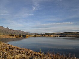
 The top of Horseshoe Reservoir looking north in December 2015 | |
| Location | Maricopa / Yavapai counties, Arizona, United States |
| Coordinates | 33°59′8.83″N 111°43′16.21″W / 33.9857861°N 111.7211694°W |
| Type | Reservoir |
| Primary inflows | Verde River |
| Primary outflows | Verde River |
| Basin countries | United States |
| Max. length | 5 miles (8.0 km) |
| Surface area | 790 acres (320 ha) |
| Average depth | 30 ft (9.1 m) |
| Max. depth | 77 ft (23 m) |
| Water volume | 109,217 acre⋅ft (134,717,000 m3) |
| Shore length1 | 27 miles (43 km) |
| Surface elevation | 2,200 ft (670 m) |
| 1 Shore length is not a well-defined measure. | |
Horseshoe Lake is a reservoir that was formed by the Horseshoe Dam on the Verde River in the U.S. state of Arizona. The lake and dam are located inside the Tonto National Forest is located upstream and north of Bartlett Lake. The dam is managed by the Salt River Project.[1][2][3][4]
References
- ^ Graziosi, Graig (July 6, 2016). "Massive fish die-off in Horseshoe Lake area". Arizona Republic. Retrieved December 10, 2019.
- ^ "Horseshoe Dam". Salt River Project. Archived from the original on December 19, 2018. Retrieved December 10, 2019.
- ^ "Horseshoe Dam". United States Bureau of Reclamation. Archived from the original on October 11, 2019. Retrieved December 10, 2019.
- ^ "Horseshoe Reservoir". United States Bureau of Agriculture. Archived from the original on December 10, 2019. Retrieved December 10, 2019.

