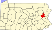
Holiday Pocono, Pennsylvania
Holiday Pocono, Pennsylvania | |
|---|---|
| Coordinates: 41°1′32″N 75°36′16″W / 41.02556°N 75.60444°W | |
| Country | United States |
| State | Pennsylvania |
| County | Carbon |
| Township | Kidder |
| Area | |
• Total | 2.39 sq mi (6.18 km2) |
| • Land | 2.35 sq mi (6.07 km2) |
| • Water | 0.04 sq mi (0.11 km2) |
| Elevation | 1,651 ft (503 m) |
| Population | |
• Total | 583 |
| • Density | 248.61/sq mi (95.98/km2) |
| Time zone | UTC-5 (Eastern (EST)) |
| • Summer (DST) | UTC-4 (EDT) |
| ZIP code | 18210[3] |
| Area code(s) | 272 and 570 |
| FIPS code | 42-35172 |
| GNIS feature ID | 1212370 |
Holiday Pocono is a residential community and census-designated place (CDP)[4] in Kidder Township, Pennsylvania, United States. It is part of Northeastern Pennsylvania.
The community is located on the north side of Pennsylvania Route 534, directly north of Albrightsville. There are two small water bodies in the CDP: Holiday Lake and Placid Lake. The western edge of the community abuts Hickory Run State Park.
| Census | Pop. | Note | %± |
|---|---|---|---|
| 2020 | 583 | — | |
| U.S. Decennial Census[5] | |||
References
- ^ "ArcGIS REST Services Directory". United States Census Bureau. Retrieved October 12, 2022.
- ^ "Census Population API". United States Census Bureau. Retrieved October 12, 2022.
- ^ "Holiday Pocono PA ZIP Code". zipdatamaps.com. 2023. Retrieved October 31, 2023.
- ^ "2010 U.S. Census website". United States Census Bureau. Retrieved September 17, 2016.
- ^ "Census of Population and Housing". Census.gov. Retrieved June 4, 2016.
Education
It is in the Jim Thorpe Area School District.[1]
External links
- ^ "2020 CENSUS - SCHOOL DISTRICT REFERENCE MAP: Carbon County, PA" (PDF). U.S. Census Bureau. Retrieved October 30, 2024. - Text list


