Hino, Tottori
Hino 日野町 | |
|---|---|
Town | |
 Hino Town Office, Hino, Tottori Prefecture | |
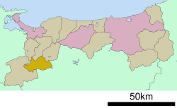
 Location of Hino in Tottori Prefecture | |
 | |
| Coordinates: 35°14′N 133°27′E / 35.233°N 133.450°E | |
| Country | Japan |
| Region | Chūgoku San'in |
| Prefecture | Tottori |
| District | Hino |
| Area | |
• Total | 133.98 km2 (51.73 sq mi) |
| Population (January 1, 2023) | |
• Total | 2,840 |
| • Density | 21/km2 (55/sq mi) |
| Time zone | UTC+9 (Japan Standard Time) |
| City symbols | |
| • Tree | Japanese cedar |
| • Flower | Azalea |
| • Bird | Mandarin duck |
| Phone number | 0859-72-0331 |
| Address | 101 Neu, Hino-chō, Hino-gun, Tottori-ken 689-4503 |
| Website | Official website(in Japanese) |
Hino (日野町, Hino-chō) is a town located in Hino District, Tottori Prefecture, Japan.[1]As of 1 August 2024, the town had an estimated population of 2,649 in 1238 households and a population density of 21 persons per km².[2] The total area of the town is 133.98 square kilometres (51.73 sq mi)
Geography
Hino is located in the Chūgoku Mountains in western Tottori Prefecture. The town center is located around the JR West Hakubi Line Neu Station.[3]
Neighboring municipalities
Tottori Prefecture
Okayama Prefecture
Climate
Hino is classified as a Humid subtropical climate (Köppen Cfa) characterized by warm summers and cold winters with heavy snowfall. The average annual temperature in Hino is 11.9 °C. The average annual rainfall is 1883 mm with September as the wettest month. The temperatures are highest on average in August, at around 23.6 °C, and lowest in January, at around 0.1 °C.[4]
Demography
Per Japanese census data,[5] the population of Hino has been as follows. The town has been suffering from rural depopulation, and the population has been continuously decreasing rapidly since the 1950s.
| Year | Pop. | ±% |
|---|---|---|
| 1920 | 8,069 | — |
| 1930 | 7,960 | −1.4% |
| 1940 | 8,004 | +0.6% |
| 1950 | 9,542 | +19.2% |
| 1960 | 8,701 | −8.8% |
| 1970 | 6,757 | −22.3% |
| 1980 | 6,092 | −9.8% |
| 1990 | 5,377 | −11.7% |
| 2000 | 4,516 | −16.0% |
| 2010 | 3,758 | −16.8% |
History
The area of Hino was part of ancient Hōki Province. Yayoi period and Kofun period remains have been found in the area. In the Sengoku period (1467 – 1573) the Hino clan built Kagamiyama Castle on Mount Kagami (335 metres (1,099 ft)) in the Kurosaka area of Hino.[1] The small-scale castle consisted of only honmaru inner bailey and a ni-no-maru outer bailey. Packhorses were also kept at the castle. A castle town was built at the base of the mountain.[6] In 1632 the Ikeda clan destroyed the castle, and used the site as an encampment. In the Edo period (1603 – 1868) the village of Neu became a shukuba post town. The commercial and administrative activities of the present-day Hino shifted to the Neu, where they remain today.[1]
During the Edo Period, it was part of the holdings of the Ikeda clan of Tottori Domain. The extraction of iron sand from the mountains and the production of tatara iron were important industries in this area until the rise of modern iron production in the modern era. Following the Meiji restoration the area was divided into villages within Hino District, Tottori on October 1, 1889 with the establishment of the modern municipalities system. The town of Hino was formed on May 1, 1959 by the merger of the towns of Kurosaka and Neu.
Government
Hino has a mayor-council form of government with a directly elected mayor and a unicameral town council of ten members. Hino, collectively with the other municipalities of Hino District, contributes one member to the Tottori Prefectural Assembly. In terms of national politics, the town is part of Tottori 2nd district of the lower house of the Diet of Japan.
Economy
The economy of Hino is based agriculture and seasonal tourism.
Education
Hino has two public elementary schools and one public junior high school operated by the town government, and one public high school operated by the Tottori Prefectural Board of Education.
Transportation
Railway
Highways
Local attractions
References
- ^ a b c d e "日野(町)" [Hino]. Nihon Daihyakka Zensho (Nipponika) (in Japanese). Tokyo: Shogakukan. 2012. OCLC 153301537. Archived from the original on August 25, 2007. Retrieved 2012-07-10.
- ^ "Hino town official statistics" (in Japanese). Japan.
- ^ まちの人口・世帯 [Town Population, Households] (in Japanese). Hino, Tottori Prefecture: Town of Hino. 2012. Retrieved July 10, 2012.
- ^ Hino climate data
- ^ Hino population statistics
- ^ "鏡山城跡" [Kagamiyama Castle remains]. Nihon Rekishi Chimei Taikei (in Japanese). Tokyo: Shogakukan. 2012. OCLC 173191044. dlc 2009238904. Archived from the original on August 25, 2007. Retrieved 2012-07-10.
- ^ 金持神社(in Japanese)
External links
![]() Media related to Hino, Tottori at Wikimedia Commons
Media related to Hino, Tottori at Wikimedia Commons
- Official town website (in Japanese)


