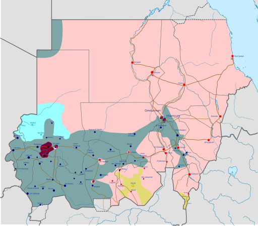
File:War in Sudan (2023).svg

Size of this PNG preview of this SVG file: 512 × 450 pixels. Other resolutions: 273 × 240 pixels | 546 × 480 pixels | 874 × 768 pixels | 1,165 × 1,024 pixels | 2,330 × 2,048 pixels.
Original file (SVG file, nominally 512 × 450 pixels, file size: 6.91 MB)
File history
Click on a date/time to view the file as it appeared at that time.
| Date/Time | Thumbnail | Dimensions | User | Comment | |
|---|---|---|---|---|---|
| current | 16:58, 16 January 2025 |  | 512 × 450 (6.91 MB) | Miki1234568 | Update: Jan 16, Gov captured 1 village on Gezira + last set of clarifications since last update in december |
| 19:21, 15 January 2025 |  | 512 × 450 (6.8 MB) | Miki1234568 | fixes | |
| 19:17, 15 January 2025 |  | 512 × 450 (6.8 MB) | Miki1234568 | Update: Jan 15, Gov captured 1 village on Gezira and 2 villiges on Kordofan + clarifications that wasn't put on prev picture | |
| 15:44, 14 January 2025 |  | 512 × 450 (6.65 MB) | Miki1234568 | Update: Jan 14, Gov captured Wad Madani | |
| 14:40, 12 January 2025 |  | 512 × 450 (5.7 MB) | Miki1234568 | Reverted to version as of 10:39, 3 December 2024 (UTC) | |
| 14:39, 12 January 2025 |  | 2,330 × 2,047 (2.05 MB) | Miki1234568 | Update: Jan 12, Gov captured Wad Madani | |
| 10:39, 3 December 2024 |  | 512 × 450 (5.7 MB) | Borysk5 | Updated: Singa and Dinder recaptured by SAF | |
| 09:02, 23 October 2024 |  | 512 × 450 (5.7 MB) | Borysk5 | Governemnt recaptured Jebel Moya cutting off RSF in Sinja region | |
| 23:02, 19 August 2024 |  | 512 × 450 (5.76 MB) | GGOTCC | This version of the file should be the most recent and should render correctly when opened | |
| 16:26, 19 August 2024 |  | 1,654 × 1,453 (5.85 MB) | GGOTCC | Most recent maps, uploaded by me, break format |
File usage
The following 19 pages use this file:
- 2020s in military history
- 2024 Darfur Ilyushin Il-76 shootdown
- Battle of Dilling
- Battle of Kadugli
- Battle of Nyala
- Battle of Wad Madani
- Darfur campaign
- Failed state
- Hemedti
- List of engagements during the Sudanese civil war (2023–present)
- Sennar offensive
- Siege of El Fasher
- Siege of El Obeid
- Sudan
- Sudan Liberation Movement/Army
- Sudanese civil war (2023–present)
- User:Khronicle I/sandbox
- Wikipedia:Top 25 Report/April 23 to 29, 2023
- File talk:2023 Sudan clashes.svg
Global file usage
The following other wikis use this file:
- Usage on af.wikipedia.org
- Usage on ar.wikipedia.org
- Usage on az.wikipedia.org
- Usage on be.wikipedia.org
- Usage on bn.wikipedia.org
- Usage on ca.wikipedia.org
- Usage on ckb.wikipedia.org
- Usage on cs.wikipedia.org
- Usage on de.wikipedia.org
- Usage on dv.wikipedia.org
- Usage on el.wikipedia.org
- Usage on es.wikipedia.org
- Usage on et.wikipedia.org
- Usage on fa.wikipedia.org
- Usage on fi.wikipedia.org
- Usage on fr.wikipedia.org
- Usage on he.wikipedia.org
- Usage on hr.wikipedia.org
- Usage on hu.wikipedia.org
- Usage on id.wikipedia.org
- Usage on is.wikipedia.org
- Usage on it.wikipedia.org
- Usage on ja.wikipedia.org
- Usage on ja.wikinews.org
- Usage on ko.wikipedia.org
- Usage on lt.wikipedia.org
- Usage on lv.wikipedia.org
- Usage on ms.wikipedia.org
- Usage on pl.wikipedia.org
- Usage on pnb.wikipedia.org
- Usage on pt.wikipedia.org
View more global usage of this file.
