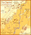
File:Tres Zapotes site plan.svg

Size of this PNG preview of this SVG file: 536 × 595 pixels. Other resolutions: 216 × 240 pixels | 432 × 480 pixels | 692 × 768 pixels | 922 × 1,024 pixels | 1,845 × 2,048 pixels.
Original file (SVG file, nominally 536 × 595 pixels, file size: 198 KB)
File history
Click on a date/time to view the file as it appeared at that time.
| Date/Time | Thumbnail | Dimensions | User | Comment | |
|---|---|---|---|---|---|
| current | 13:38, 7 March 2008 |  | 536 × 595 (198 KB) | Madman2001 | needed to pathicize an object |
| 13:34, 7 March 2008 |  | 539 × 597 (184 KB) | Madman2001 | small fixes | |
| 23:22, 6 March 2008 |  | 539 × 597 (198 KB) | Madman2001 | tinkered with colors to match Olmec heartland map | |
| 18:54, 6 March 2008 |  | 539 × 597 (195 KB) | Madman2001 | Tres Zapotes Archaeological Site | |
| 18:38, 6 March 2008 |  | 539 × 597 (194 KB) | Madman2001 | {{Information |Description= |Source=self-made |Date=March 08 |Author= Madman2001 |Permission= |other_versions= }} Tres Zapotes Category:Archaeological maps [[Category:Epi-Olmec cultur |
File usage
The following 2 pages use this file:
Global file usage
The following other wikis use this file:
- Usage on bn.wikipedia.org
- Usage on de.wikipedia.org
- Usage on es.wikipedia.org
- Usage on fr.wikipedia.org
- Usage on ha.wikipedia.org
- Usage on hu.wikipedia.org
- Usage on it.wikipedia.org
- Usage on ja.wikipedia.org
- Usage on pl.wikipedia.org
- Usage on sv.wikipedia.org
- Usage on uk.wikipedia.org
