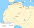
File:Trans-Saharan roman expeditions-explorations.png

Size of this preview: 719 × 599 pixels. Other resolutions: 288 × 240 pixels | 576 × 480 pixels.
Original file (800 × 667 pixels, file size: 60 KB, MIME type: image/png)
File history
Click on a date/time to view the file as it appeared at that time.
| Date/Time | Thumbnail | Dimensions | User | Comment | |
|---|---|---|---|---|---|
| current | 18:56, 12 June 2015 |  | 800 × 667 (60 KB) | Fixwikimaps | Reverted to version as of 19:20, 3 June 2015 |
| 19:21, 3 June 2015 |  | 500 × 583 (95 KB) | Fixwikimaps | Reverted to version as of 23:19, 17 February 2015 | |
| 19:20, 3 June 2015 |  | 800 × 667 (60 KB) | Fixwikimaps | Updated the map to better reflect the areas in Africa that were explored in Africa. The extent was widened, colors were adjusted, and legend was cleaned up. Map was completed by Hans van der Maarel of Red Geographics | |
| 23:19, 17 February 2015 |  | 500 × 583 (95 KB) | Cresthaven | User created page with UploadWizard |
File usage
The following 5 pages use this file:
Global file usage
The following other wikis use this file:
- Usage on ar.wikipedia.org
- Usage on ca.wikipedia.org
- Usage on es.wikipedia.org
- Usage on fr.wikipedia.org
- Usage on pt.wikipedia.org
- Usage on ru.wikipedia.org
- Usage on uk.wikipedia.org
