File:Teideform2.png

Size of this preview: 504 × 600 pixels. Other resolutions: 202 × 240 pixels | 588 × 700 pixels.
Original file (588 × 700 pixels, file size: 58 KB, MIME type: image/png)
File history
Click on a date/time to view the file as it appeared at that time.
| Date/Time | Thumbnail | Dimensions | User | Comment | |
|---|---|---|---|---|---|
| current | 09:01, 1 February 2008 |  | 588 × 700 (58 KB) | Xiong Chiamiov | optimized using optipng |
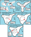
| 14:18, 9 October 2007 |  | 588 × 700 (96 KB) | ExtraFossiliferous | This is a very schematic diagram of the formation of the island of Tenerife and evolution of the current Teide volcano. In step one the island began as three separate shield volcanoes - Anaga to the NE, Teno to the NW and Roque del Conde to the south. Ste | |
| 14:12, 9 October 2007 |  | 588 × 700 (96 KB) | ExtraFossiliferous | {{Information |Description=This is a very schematic diagram of the formation of the island of Tenerife and evolution of the current Teide volcano. In step one the island began as three separate shield volcanoes - Anaga to the NE, Teno to the NW and Roque |
File usage
The following page uses this file:
Global file usage
The following other wikis use this file:

