Langbahn Team – Weltmeisterschaft

File:Tang outline map, 661.svg
Original file (SVG file, nominally 1,288 × 757 pixels, file size: 64 KB)

Summary

Description
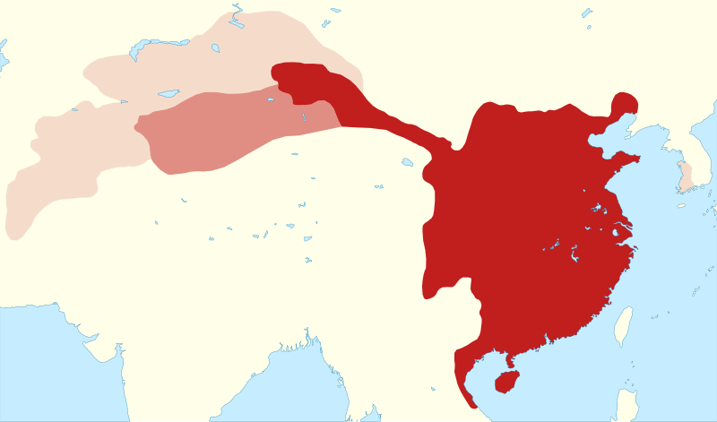
English: Outline map of the Tang empire in 661, when it reached its greatest extent.
Map legend
 
civil administration
 
military administration (Anxi protectorate): 649–670 and 675–755
 
briefly-controlled areas: Kunling, Mengchi, Sogdiana and Tokharistan protectorates (established 657–661, overthrown 665), Ungjin Commandery (660–671)
Date
Source

Own work

  • Boundaries from
    • Twitchett, Denis and Wechsler, Howard J. (1979), "Kao-tsung (reign 649–83) and the Empress Wu: The Inheritor and the Usurper", in Denis Twitchett and John Fairbank (eds.), The Cambridge History of China, Volume 3: Sui and T'ang China, 589–906, Part I, Cambridge University Press, ISBN 978-0-521-21446-9, Maps 8 (p. 281) and 9 (p. 283).
    • Blunden, Caroline and Elvin, Mark (1983), Cultural Atlas of China, Oxford: Phaidon Press, ISBN 0-7148-2309-0, pp. 26, 92–93.
    • Shin, Michael D. , ed. (2014) Korean History in Maps, Cambridge University Press, pp. 39, 47 ISBN: 978-1-107-09846-6. (pre-conquest extent of Baekje, approximating the extent of the Ungjin Commandery)
  • Coastline and lakes from Natural Earth 1:50m Physical Vectors
  • Conversion to SVG using svgis
Creator
 Geotemporal data
Date depicted
Spatial reference system equirectangular
Heading
Bounding box
N: 50°N
W: 61°E E: 130°E
S: 16°N
Other versions
SVG development
InfoField
 
The SVG code is valid.
 
This map was created with svgis.

Licensing

I, the copyright holder of this work, hereby publish it under the following licenses:
w:en:Creative Commons
attribution share alike
This file is licensed under the Creative Commons Attribution-Share Alike 4.0 International license.
You are free:
  • to share – to copy, distribute and transmit the work
  • to remix – to adapt the work
Under the following conditions:
  • attribution – You must give appropriate credit, provide a link to the license, and indicate if changes were made. You may do so in any reasonable manner, but not in any way that suggests the licensor endorses you or your use.
  • share alike – If you remix, transform, or build upon the material, you must distribute your contributions under the same or compatible license as the original.
GNU head Permission is granted to copy, distribute and/or modify this document under the terms of the GNU Free Documentation License, Version 1.2 or any later version published by the Free Software Foundation; with no Invariant Sections, no Front-Cover Texts, and no Back-Cover Texts. A copy of the license is included in the section entitled GNU Free Documentation License.
You may select the license of your choice.

Captions

Add a one-line explanation of what this file represents

Items portrayed in this file

depicts

copyright status

copyrighted

copyright license

Creative Commons Attribution-ShareAlike 4.0 International

GNU Free Documentation License, version 1.2 or later

source of file

original creation by uploader

media type

image/svg+xml

File history

Click on a date/time to view the file as it appeared at that time.

Date/TimeThumbnailDimensionsUserComment
current07:48, 27 March 2024Thumbnail for version as of 07:48, 27 March 20241,288 × 757 (64 KB)Kanguolefix XML markup errors (bad characters in id's)
22:52, 24 March 2024Thumbnail for version as of 22:52, 24 March 20241,288 × 757 (64 KB)Kanguoleminor update to northern boundary
20:46, 22 June 2023Thumbnail for version as of 20:46, 22 June 20231,288 × 757 (63 KB)Kanguoleadd Ungjin Commandery (660–671)
15:18, 7 May 2023Thumbnail for version as of 15:18, 7 May 20231,195 × 757 (56 KB)Kanguole{{Map |Description={{en|1=Outline map of the Tang empire in 661, when it reached its greatest extent.}} |Legend= {{legend|#c11e1e|civil administration}} {{legend|#df8d83|military administration (Anxi protectorate): 649–670 and 675–755}} {{legend|#f7dcca|briefly-controlled protectorates (Kunling, Mengchi, Sogdiana, Tokharistan): established 657–661, overthrown 665}} |Date=2023-05-07 |Source={{own}} * Boundaries from ** Twitchett, Denis and Wechsler, Howard J. (1979). "Kao-tsung (reign 649-83)...

Global file usage

The following other wikis use this file:

Metadata