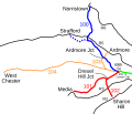
File:Red Arrow map.svg

Size of this PNG preview of this SVG file: 699 × 600 pixels. Other resolutions: 280 × 240 pixels | 560 × 480 pixels | 895 × 768 pixels | 1,194 × 1,024 pixels | 2,388 × 2,048 pixels | 991 × 850 pixels.
Original file (SVG file, nominally 991 × 850 pixels, file size: 41 KB)
File history
Click on a date/time to view the file as it appeared at that time.
| Date/Time | Thumbnail | Dimensions | User | Comment | |
|---|---|---|---|---|---|
| current | 22:54, 20 December 2016 |  | 991 × 850 (41 KB) | Pi.1415926535 | Expand 10x for better thumbnail on file page |
| 00:07, 1 November 2005 |  | 100 × 85 (41 KB) | SPUI~commonswiki | {{spuimap}} Map of the former Red Arrow trolley lines, now run by SEPTA, traced on USGS topos. Blue (100) is the Norristown High Speed Line, red (101 and 102) is the Media and Sharon Hill lines, and orange (103 and 104) is former trolley lines, now bus. R |
File usage
The following 6 pages use this file:
Global file usage
The following other wikis use this file:
- Usage on de.wikipedia.org
- Usage on es.wikipedia.org
- Usage on it.wikipedia.org
- Usage on ja.wikipedia.org
- Usage on ko.wikipedia.org
- Usage on nl.wikipedia.org
- Usage on no.wikipedia.org
- Usage on www.wikidata.org
