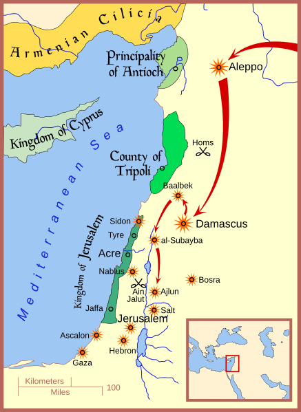
File:Mongol raids in Syria and Palestine 1260.svg

Size of this PNG preview of this SVG file: 437 × 599 pixels. Other resolutions: 175 × 240 pixels | 350 × 480 pixels | 560 × 768 pixels | 747 × 1,024 pixels | 1,493 × 2,048 pixels | 657 × 901 pixels.
Original file (SVG file, nominally 657 × 901 pixels, file size: 316 KB)
File history
Click on a date/time to view the file as it appeared at that time.
| Date/Time | Thumbnail | Dimensions | User | Comment | |
|---|---|---|---|---|---|
| current | 13:46, 24 March 2021 |  | 657 × 901 (316 KB) | Dimash Kenesbek | Reverted to version as of 17:09, 19 June 2008 (UTC) |
| 13:44, 24 March 2021 |  | 657 × 901 (342 KB) | Dimash Kenesbek | File uploaded using svgtranslate tool (https://svgtranslate.toolforge.org/). Added translation for kk-cyrl. | |
| 13:43, 24 March 2021 |  | 657 × 901 (330 KB) | Dimash Kenesbek | File uploaded using svgtranslate tool (https://svgtranslate.toolforge.org/). Added translation for kk-cyrl. | |
| 17:09, 19 June 2008 |  | 657 × 901 (316 KB) | MapMaster | small fixes and improvements | |
| 16:22, 19 June 2008 |  | 657 × 901 (287 KB) | MapMaster | Adjusted area for Kingdom of Jerusalem, added Jaffa | |
| 16:05, 13 June 2008 |  | 657 × 901 (284 KB) | MapMaster | added Sidon | |
| 02:38, 12 June 2008 |  | 657 × 901 (277 KB) | MapMaster | minor edits | |
| 02:11, 11 June 2008 |  | 657 × 901 (276 KB) | MapMaster |
File usage
The following 12 pages use this file:
- Ayyubid dynasty
- Bohemond VI of Antioch
- Hugh II of Cyprus
- List of conflicts in Asia
- Mongol Armenia
- Mongol invasions of the Levant
- Mongol raids into Palestine
- Qutuz
- Talk:Mongol raids into Palestine
- User:Falcaorib/Medieval Empires (1200-1300 AD)
- User:Joelton Ivson/Gather lists/24305 – Mongóis
- File talk:Mongol raids in Syria and Palestine 1260.svg
Global file usage
The following other wikis use this file:
- Usage on af.wikipedia.org
- Usage on arz.wikipedia.org
- Usage on azb.wikipedia.org
- Usage on az.wikipedia.org
- Usage on be.wikipedia.org
- Usage on bg.wikipedia.org
- Usage on bn.wikipedia.org
- Usage on ca.wikipedia.org
- Usage on da.wikipedia.org
- Usage on eo.wikipedia.org
- Usage on et.wikipedia.org
- Usage on fa.wikipedia.org
- Usage on fi.wikipedia.org
- Usage on fr.wikipedia.org
- Usage on he.wikipedia.org
- Usage on id.wikipedia.org
- Usage on ja.wikipedia.org
- Usage on ka.wikipedia.org
- Usage on mk.wikipedia.org
- Usage on ms.wikipedia.org
- Usage on pl.wikipedia.org
- Usage on ro.wikipedia.org
- Usage on ru.wikipedia.org
- Usage on sr.wikipedia.org
- Usage on sv.wikipedia.org
- Usage on tr.wikipedia.org
- Usage on uk.wikipedia.org
- Usage on uz.wikipedia.org
- Usage on www.wikidata.org
- Usage on zh.wikipedia.org


