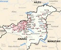
File:Maubisse posto administrativo.png

Size of this preview: 720 × 599 pixels. Other resolutions: 288 × 240 pixels | 577 × 480 pixels | 882 × 734 pixels.
Original file (882 × 734 pixels, file size: 624 KB, MIME type: image/png)
File history
Click on a date/time to view the file as it appeared at that time.
| Date/Time | Thumbnail | Dimensions | User | Comment | |
|---|---|---|---|---|---|
| current | 17:56, 12 March 2012 |  | 882 × 734 (624 KB) | J. Patrick Fischer | River Aicocai added |
| 12:56, 20 June 2010 |  | 882 × 734 (315 KB) | J. Patrick Fischer | typo: Caimauk -> Caimauc | |
| 20:57, 1 December 2009 |  | 882 × 734 (273 KB) | J. Patrick Fischer | New geographical names and spelling according Ministerial Document 199/2009, http://www.jornal.gov.tl/public/docs/2009/serie_1/serie1_no33.pdf | |
| 12:32, 6 November 2009 |  | 882 × 734 (269 KB) | J. Patrick Fischer | Some Village names were missing | |
| 08:58, 13 October 2009 |  | 882 × 734 (263 KB) | J. Patrick Fischer | {{Information |Description={{en|1=The subdistrict of Maubisse, district Ainaro, East Timor}} {{de|1=Subdistrikt Maubisse, Distrikt Ainaro, Osttimor}} |Source=Eigenes Werk unter Verwendung von [[:File:Administrative map of the Ainaro district of East Timor |
File usage
The following page uses this file:
Global file usage
The following other wikis use this file:
- Usage on de.wikipedia.org
- Usage on de.wikivoyage.org
- Usage on el.wikipedia.org
- Usage on pl.wikipedia.org
- Usage on tet.wikipedia.org
- Usage on ur.wikipedia.org
- Usage on www.wikidata.org
- Usage on zh.wikipedia.org
