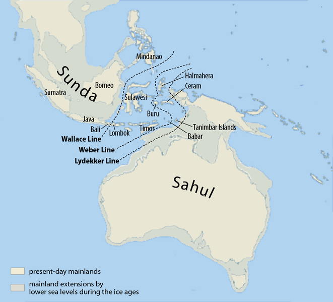
File:Map of Sunda and Sahul.png

Size of this preview: 661 × 599 pixels. Other resolutions: 265 × 240 pixels | 530 × 480 pixels | 847 × 768 pixels | 1,111 × 1,007 pixels.
Original file (1,111 × 1,007 pixels, file size: 208 KB, MIME type: image/png)
File history
Click on a date/time to view the file as it appeared at that time.
| Date/Time | Thumbnail | Dimensions | User | Comment | |
|---|---|---|---|---|---|
| current | 08:07, 5 March 2017 |  | 1,111 × 1,007 (208 KB) | Chumwa | corr |
| 06:46, 25 July 2009 |  | 1,111 × 1,007 (269 KB) | Chumwa | Inseln -> Islands | |
| 06:13, 25 July 2009 |  | 1,111 × 1,007 (268 KB) | Chumwa | {{Information |Description= {{ de }}Karte von Sunda und Sahul sowie der Wallace-Linie, der Lydekker-Linie und der Weber-Linie. * Als Sahul wird die zusammenhängende Landmasse bezeichnet, die während der letzten Eiszeit aus Australien, der nordöstlich d |
File usage
The following 14 pages use this file:
- Australia (continent)
- Canis lupus dingo
- Denisovan
- Dingo
- List of butterflies of the Philippines
- Lost lands
- Models of migration to the Philippines
- New Guinea singing dog
- Red-naped trogon
- Sahul Shelf
- User:Cruickshanks/Sandbox
- User:Obsidian Soul/sandbox
- Wikipedia:Categories for discussion/Log/2015 June 26
- Wikipedia:Reference desk/Archives/Science/2011 May 15
Global file usage
The following other wikis use this file:
- Usage on ar.wikipedia.org
- Usage on ast.wikipedia.org
- Usage on az.wikipedia.org
- Usage on be.wikipedia.org
- Usage on bg.wikipedia.org
- Usage on bn.wikipedia.org
- Usage on ca.wikipedia.org
- Usage on cs.wikipedia.org
- Usage on de.wikipedia.org
- Usage on eo.wikipedia.org
- Usage on es.wikipedia.org
- Usage on fa.wikipedia.org
- Usage on fi.wikipedia.org
- Usage on fr.wikipedia.org
- Usage on gl.wikipedia.org
- Usage on he.wikipedia.org
- Usage on hi.wikipedia.org
- Usage on hr.wikipedia.org
View more global usage of this file.


