Langbahn Team – Weltmeisterschaft

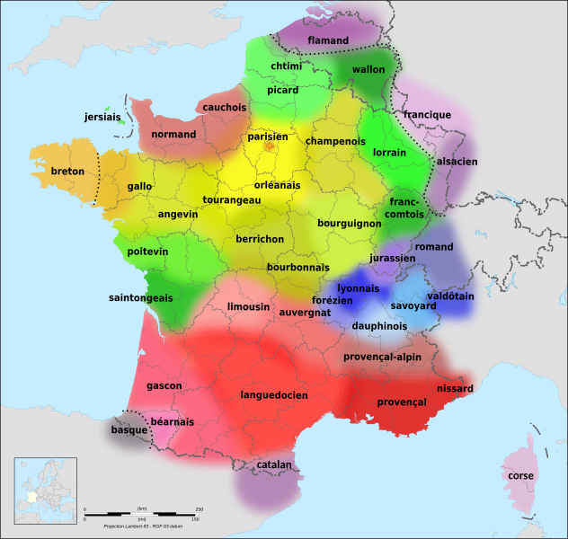
File:Langues de la France.svg
Original file (SVG file, nominally 2,000 × 1,898 pixels, file size: 1.18 MB)

Summary

Description
  • العربية: خريطة للغات ولهجات فرنسا وبلجيكا والمناطق الحدودية.
  • Català: Un mapa de les llengües i dialectes de França i Bèlgica i les regions frontereres.
  • Dansk: Et kort over sprog og dialekter i Frankrig og Belgien og grænseregionerne.
  • Deutsch: Eine Karte der Sprachen und Dialekte in Frankreich und Belgien sowie der Grenzregionen.
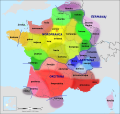
  • English: A map of the languages and dialects of France and Belgium and the border regions.
  • Esperanto: Mapo de la lingvoj kaj dialektoj de Francio kaj Belgio kaj la landlimaj regionoj.
  • Español: Mapa de las lenguas y dialectos de Francia y Bélgica y de las regiones fronterizas.
  • Euskara: Frantziako eta Belgikako eta mugako eskualdeetako hizkuntzen eta dialektoen mapa.
  • Français : Une carte des langues et dialectes de la France et de la Belgique et des régions frontalières.
  • Italiano: Una mappa delle lingue e dei dialetti di Francia e Belgio e delle regioni di confine.
  • Nederlands: Een kaart van de talen en dialecten van Frankrijk en België en de grensregio's.
  • Português: Um mapa das línguas e dialectos de França e da Bélgica e das regiões fronteiriças.
  • Română: O hartă a limbilor și dialectelor din Franța și Belgia și a regiunilor de frontieră.
  • Русский: Карта языков и диалектов Франции и Бельгии, а также приграничных регионов.
  • Svenska: En karta över språken och dialekterna i Frankrike och Belgien och gränsregionerna.
  • Українська: Карта мов і діалектів Франції та Бельгії, а також прикордонних регіонів.
Date (UTC)
Source
Author
Other versions


SVG development
InfoField
 
The SVG code is valid.
 
This map was created with Inkscape.
 
 This map uses embedded text that can be easily translated using a text editor.

Licensing

w:en:Creative Commons
attribution share alike
This file is licensed under the Creative Commons Attribution-Share Alike 3.0 Unported license.
You are free:
  • to share – to copy, distribute and transmit the work
  • to remix – to adapt the work
Under the following conditions:
  • attribution – You must give appropriate credit, provide a link to the license, and indicate if changes were made. You may do so in any reasonable manner, but not in any way that suggests the licensor endorses you or your use.
  • share alike – If you remix, transform, or build upon the material, you must distribute your contributions under the same or compatible license as the original.


Original upload log

This image is a derivative work of the following images:

  • File:Langues de la France1.gif licensed with Attribution
    • 2009-11-11T07:57:53Z Parigot 603x599 (178168 Bytes) Colorisation du saintongeais.
    • 2008-01-21T20:48:21Z Parigot 603x599 (179774 Bytes) Finalisation des retouches géo-linguistiques
    • 2008-01-21T20:35:50Z Parigot 603x599 (179708 Bytes) {{Information |Description= |Source= |Date= |Author= |Permission= |other_versions= }}
    • 2008-01-21T20:31:20Z Parigot 603x599 (179708 Bytes) Modification poitevin et saintongeais
    • 2008-01-21T20:22:56Z Parigot 603x599 (179683 Bytes) Modification des limites linguistiques poitevine et saintongeaise.
    • 2008-01-20T18:38:48Z Parigot 603x599 (179753 Bytes) Carte des langues régionales.
    • 2007-08-12T10:05:05Z Parigot 654x650 (123918 Bytes) Nouvelle version fichier image. Ajout parler angevin
    • 2007-08-12T10:02:48Z Parigot 654x650 (123918 Bytes) Nouvelle version du fichier avec ajout du parler angevin
    • 2007-08-12T10:02:05Z Parigot 654x650 (123918 Bytes) Nouvelle version du fichier avec ajout du parler angevin
    • 2007-08-12T09:58:26Z Parigot 654x650 (123918 Bytes) Nouvelle version du fichier avec ajout du parler angevin
    • 2006-11-30T12:19:15Z Yug 654x650 (37578 Bytes) improved : Occitan => Languedocien
    • 2006-11-18T02:26:22Z Chlämens 654x650 (38730 Bytes)
    • 2006-07-27T12:53:36Z Moyogo 654x650 (37081 Bytes) removed québécois - title says 'Languages of France'.
    • 2005-04-03T11:12:50Z Chlämens 654x650 (46252 Bytes)
  • File:Départements de France-simple.svg licensed with PD-self
    • 2007-09-09T11:49:17Z Marmelad 507x553 (148302 Bytes) added a box zoomed in around Paris to show the small departements near the city, as in [[:Image:Carte France Département 95.png]] (currently hidden). For documentation on how to use this image, see [[:User:Marmelad/FRA-Map
    • 2007-09-08T17:06:31Z Marmelad 507x553 (147117 Bytes) Cleaned up the svg code for use with auto-generating software.
    • 2007-04-24T09:27:36Z Emmanuel.boutet 507x553 (184098 Bytes) {{Information |Description=Version simplifiée de [[:Image:Départements et régions de France.svg]] |Source=[[:Image:Départements et régions de France.svg]] by [[User:bayo|bayo]] |Date=2007-04-24 |Author=[[User:Emmanuel.bo

Uploaded with derivativeFX

Captions

Add a one-line explanation of what this file represents

Items portrayed in this file

depicts

copyright license

Creative Commons Attribution-ShareAlike 3.0 Unported

inception

17 February 2010

media type

image/svg+xml

File history

Click on a date/time to view the file as it appeared at that time.

(newest | oldest) View (newer 10 | ) (10 | 20 | 50 | 100 | 250 | 500)
Date/TimeThumbnailDimensionsUserComment
current14:18, 22 February 2022Thumbnail for version as of 14:18, 22 February 20222,000 × 1,898 (1.18 MB)Eowyn CwperAdded language family separator; minor label improvements and corrections
23:08, 23 February 2010Thumbnail for version as of 23:08, 23 February 20102,000 × 1,898 (1.21 MB)Hellotheworld{{en|(almost?) final version of the file, changing the Font to 'DejaVu' (improving MediaWiki compatibility)+ improving colors for better readeability}} {{fr|version (presque ?) finale du fichier, changement de la police pour 'DejaVu' (ce qui améliore la
22:46, 18 February 2010Thumbnail for version as of 22:46, 18 February 20102,000 × 1,898 (1.21 MB)Hellotheworldminor modification. {{en|blur improvment.}} {{fr|amélioration du flou sur les zones linguistiques}}
20:50, 18 February 2010Thumbnail for version as of 20:50, 18 February 20102,000 × 1,898 (1.21 MB)Hellotheworldsuppressing a little (boring) bug of 'text melting'...
20:39, 18 February 2010Thumbnail for version as of 20:39, 18 February 20102,000 × 1,898 (1.21 MB)Hellotheworld{{New major update, still thanks to the Atelier Graphique... using a 'big and clean SVG original file'}} {{Nouvelle évolution majeure, toujours grâce à l'Atelier Graphique, en utilisant une 'grosse et belle image SVG originale')}}
18:52, 18 February 2010Thumbnail for version as of 18:52, 18 February 2010507 × 553 (246 KB)Hellotheworld??? ... Same player shoot again. {{fr|(on réessaye !)}}
18:50, 18 February 2010Thumbnail for version as of 18:50, 18 February 2010507 × 553 (246 KB)Hellotheworld{{fr|Amélioration majeure suite à des remarques pertinentes de l'Atelier Graphique : ajout de la mer, correction des erreurs typographiques, mise en relief du texte, "floutage" du contour des bulles...}} {{en|Major improve, next to french Atelier Graphi
00:03, 18 February 2010Thumbnail for version as of 00:03, 18 February 2010507 × 553 (220 KB)Hellotheworld{{fr|suppression du fichier BMP source, qui sert... de source, mais plante MédiaWiki}} {{en|suppressing the original BMP file, wich is... the original file, mais bugs MediaWiki}}
18:42, 17 February 2010Thumbnail for version as of 18:42, 17 February 2010507 × 553 (224 KB)Hellotheworld{{en|Finished work.}} {{fr|Fichier terminé.}}
17:27, 17 February 2010Thumbnail for version as of 17:27, 17 February 2010507 × 553 (189 KB)Hellotheworld{{en|WORK IN PROGRESS. Solved problem of "black text". This file is in progress, I created it early to not loose the sources, according to licence.}} {{fr|TRAVAIL EN COURS. Problème résolu pour les "texte en noir". Ce fichier est en cours de travail, je
(newest | oldest) View (newer 10 | ) (10 | 20 | 50 | 100 | 250 | 500)

Global file usage

The following other wikis use this file:

View more global usage of this file.
Metadata