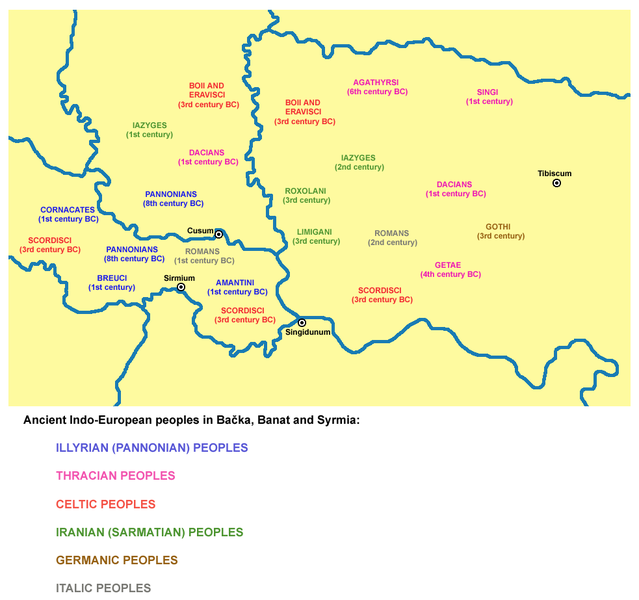
File:Indo Europeans Vojvodina map.png

Size of this preview: 639 × 600 pixels. Other resolutions: 256 × 240 pixels | 511 × 480 pixels | 983 × 923 pixels.
Original file (983 × 923 pixels, file size: 84 KB, MIME type: image/png)
File history
Click on a date/time to view the file as it appeared at that time.
| Date/Time | Thumbnail | Dimensions | User | Comment | |
|---|---|---|---|---|---|
| current | 19:45, 6 May 2014 |  | 983 × 923 (84 KB) | WikiEditor2004 | aesthetics |
| 21:33, 9 January 2014 |  | 983 × 923 (90 KB) | WikiEditor2004 | aesthetics | |
| 20:39, 12 May 2009 |  | 981 × 923 (90 KB) | WikiEditor2004 | ||
| 14:12, 18 April 2009 |  | 981 × 923 (90 KB) | WikiEditor2004 | ||
| 16:55, 6 April 2009 |  | 981 × 923 (88 KB) | WikiEditor2004 | ||
| 23:40, 9 February 2009 |  | 520 × 560 (36 KB) | WikiEditor2004 | historical map of ancient Indo-European peoples in Vojvodina (self made) {{PD-self}} Category:Maps of the history of Vojvodina |
File usage
The following 5 pages use this file:
Global file usage
The following other wikis use this file:
- Usage on el.wikipedia.org
- Usage on es.wikipedia.org
- Usage on gl.wikipedia.org
- Usage on ja.wikipedia.org
- Usage on lt.wikipedia.org
- Usage on mk.wikipedia.org
- Usage on ro.wikipedia.org
- Usage on sh.wikipedia.org
- Usage on sq.wikipedia.org
