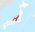
File:Hokuriku Shin'etsu Region in Japan.svg

Size of this PNG preview of this SVG file: 413 × 373 pixels. Other resolutions: 266 × 240 pixels | 532 × 480 pixels | 850 × 768 pixels | 1,134 × 1,024 pixels | 2,268 × 2,048 pixels.
Original file (SVG file, nominally 413 × 373 pixels, file size: 950 KB)
File history
Click on a date/time to view the file as it appeared at that time.
| Date/Time | Thumbnail | Dimensions | User | Comment | |
|---|---|---|---|---|---|
| current | 05:11, 18 October 2022 |  | 413 × 373 (950 KB) | そらみみ | Notojima, Awashima |
| 05:08, 18 October 2022 |  | 413 × 373 (950 KB) | そらみみ | Uploaded a work by {{own}} from File:Japan location map with side map of the Ryukyu Islands.svg(アップロード者はMaximilian Dörrbecker (Chumwa))を元に作成。 with UploadWizard |
File usage
The following 2 pages use this file:
Global file usage
The following other wikis use this file:
- Usage on ja.wikipedia.org
- Usage on ko.wikipedia.org
- Usage on zh.wikipedia.org
