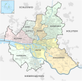
File:Hamburg Subdivisions.svg

Size of this PNG preview of this SVG file: 608 × 599 pixels. Other resolutions: 243 × 240 pixels | 487 × 480 pixels | 779 × 768 pixels | 1,039 × 1,024 pixels | 2,077 × 2,048 pixels | 1,713 × 1,689 pixels.
Original file (SVG file, nominally 1,713 × 1,689 pixels, file size: 1.11 MB)
File history
Click on a date/time to view the file as it appeared at that time.
| Date/Time | Thumbnail | Dimensions | User | Comment | |
|---|---|---|---|---|---|
| current | 21:05, 1 January 2013 |  | 1,713 × 1,689 (1.11 MB) | TUBS | Steils -hoop |
| 21:26, 23 January 2012 |  | 1,713 × 1,689 (2.14 MB) | TUBS | corr "Ottensen" & "Sasel" | |
| 08:30, 6 January 2011 |  | 1,713 × 1,689 (2.14 MB) | TUBS | aktualisiert | |
| 09:02, 31 May 2010 |  | 560 × 549 (1.93 MB) | TUBS | Marienthall is actually Marienthal | |
| 20:20, 26 May 2010 |  | 560 × 549 (1.94 MB) | TUBS | {{Information |Description={{de|Karte der Verwaltungsgliederung Hamburgs.}} {{en|Map of administrative divisions of Hamburg.}} |Source={{own}}{{Adobe Illustrator}}{{Commonist}}</br>Based on: *[[:File:Hamburg location map.s |
File usage
The following 3 pages use this file:
Global file usage
The following other wikis use this file:
- Usage on an.wikipedia.org
- Usage on arc.wikipedia.org
- Usage on ca.wikipedia.org
- Usage on de.wikipedia.org
- Usage on es.wikipedia.org
- Usage on ga.wikipedia.org
- Usage on hr.wikipedia.org
- Usage on lmo.wikipedia.org
- Usage on mk.wikipedia.org
- Usage on no.wikipedia.org
- Usage on pt.wikipedia.org
- Usage on rm.wikipedia.org
- Usage on sl.wikipedia.org
- Usage on sv.wikipedia.org
- Usage on vi.wikipedia.org
- Usage on zh-min-nan.wikipedia.org


