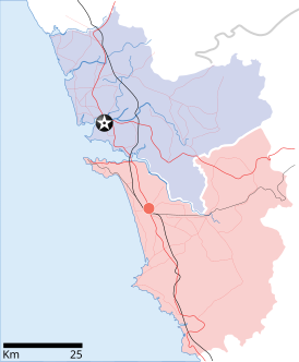
File:Goa locator map.svg

Size of this PNG preview of this SVG file: 274 × 331 pixels. Other resolutions: 199 × 240 pixels | 397 × 480 pixels | 636 × 768 pixels | 848 × 1,024 pixels | 1,695 × 2,048 pixels.
Original file (SVG file, nominally 274 × 331 pixels, file size: 93 KB)
File history
Click on a date/time to view the file as it appeared at that time.
| Date/Time | Thumbnail | Dimensions | User | Comment | |
|---|---|---|---|---|---|
| current | 10:48, 26 April 2007 |  | 274 × 331 (93 KB) | Planemad | upd |
| 10:40, 26 April 2007 |  | 274 × 331 (80 KB) | Planemad | upd | |
| 18:27, 9 April 2007 |  | 274 × 331 (66 KB) | Planemad | {{WikiProject_India_Maps |Title=Goa locator map |Description=Locator map for the state of [w:Goa]] |Source= [http://www.bombayproperty.com/goamap.jpg Map of Goa], |Date=April 2007 |Author=w:user:Planemad }} Category:WikiProject India State Maps |
File usage
More than 100 pages use this file. The following list shows the first 100 pages that use this file only. A full list is available.
- Adas Bank
- Agaçaim
- Agonda
- Altinho, Goa
- Amona, Goa
- Aquem
- Arpora
- Assagao
- Assonora
- Baga, Goa
- Baga Creek
- Bambolim
- Bandora, Goa
- Bardez taluka
- Batim
- Betul, Goa
- Bicholim taluka
- Bogmalo
- Borda, Goa
- Borim
- Canacona
- Candola
- Carambolim
- Caranzalem
- Carapur
- Carmona, Goa
- Cavelossim
- Chapora Beach
- Chapora River
- Chaudi
- Chicalim
- Chimbel
- Colvale
- Comba, Goa
- Curti, Goa
- Dabolim
- Dargalim Assembly constituency
- Davorlim
- Dramapur
- Farmagudi
- Fatorpa
- Flora and fauna of Goa
- Galgibaga Beach
- Gogol, Goa
- Gokarna Math
- Kasarpal
- Khandepar
- Latambarcem
- Loliem-Polem
- Maem
- Majorda
- Mapusa River
- Mardol, Goa
- Marna, Goa
- Mobor
- Moitem
- Mollem, Goa
- Mopa, Goa
- Nagoa
- Netravali
- Nuvem
- Olaulim
- Orgao
- Pale, Goa
- Pale Assembly constituency
- Paliem, Pernem, Goa.
- Parcem
- Patradevi
- Penha de França, Goa
- Pilar, Goa
- Poinguinim
- Poinguinim Assembly constituency
- Pomburpa
- Ponda Fort
- Ponda taluka
- Priol
- Quelossim
- Quepem taluka
- Querim Beach
- Queula
- Revora
- Rivona
- Sal River (India)
- Sancoale
- Sangolda
- Sanguem
- Sanguem taluka
- Sanquelim
- Sanvordem
- Sinquerim
- Sircaim
- Sonsogor
- St Inez Creek
- São Jacinto
- São José de Areal
- Terekhol River
- Valpoi
- Zambaulim
- Zuari River
- Talk:Daivadnya/Archive 1
View more links to this file.
Global file usage
The following other wikis use this file:
- Usage on ar.wikipedia.org
- Usage on ba.wikipedia.org
- Usage on ceb.wikipedia.org
- Usage on cy.wikipedia.org
- Usage on de.wikipedia.org
- Usage on fa.wikipedia.org
- Usage on gom.wikipedia.org
- Usage on gu.wikipedia.org
- Usage on id.wikipedia.org
- Usage on kbd.wikipedia.org
- Usage on ml.wikipedia.org
- Usage on ms.wikipedia.org
- Usage on nl.wikipedia.org
- Usage on or.wikipedia.org
- Usage on pam.wikipedia.org
- Usage on pa.wikipedia.org
- Usage on pl.wikipedia.org
- Usage on pt.wikipedia.org
- Usage on sa.wikipedia.org
- Usage on sco.wikipedia.org
- Usage on ta.wikipedia.org
- Usage on te.wikipedia.org
- Usage on th.wikipedia.org
- Usage on tl.wikipedia.org
- Usage on tr.wikipedia.org
- Usage on ur.wikipedia.org
- Usage on war.wikipedia.org
- Usage on www.wikidata.org
- Usage on zh.wikipedia.org
