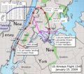
File:Flight 1549-OptionsNotTaken.PNG

Size of this preview: 686 × 600 pixels. Other resolutions: 275 × 240 pixels | 549 × 480 pixels | 1,000 × 874 pixels.
Original file (1,000 × 874 pixels, file size: 727 KB, MIME type: image/png)
File history
Click on a date/time to view the file as it appeared at that time.
| Date/Time | Thumbnail | Dimensions | User | Comment | |
|---|---|---|---|---|---|
| current | 11:59, 12 February 2019 |  | 1,000 × 874 (727 KB) | Chrysfrom Houston | Direction of the Canadian Geese Flock was in error (reversed). Now fixed. Other tweaks made also. |
| 01:23, 14 September 2017 |  | 1,000 × 874 (775 KB) | Tuntable | Added location and time of the actual bird strike. | |
| 02:53, 5 June 2016 |  | 1,000 × 874 (731 KB) | ChrisnHouston | Re-adding Teterboro runway diagram, to scale. | |
| 23:25, 26 December 2015 |  | 1,000 × 874 (836 KB) | MIDI | Reverted to version as of 19:42, 12 March 2010 (UTC) Map/sat overlay is not free-use | |
| 04:29, 18 February 2012 |  | 1,000 × 874 (831 KB) | ChrisnHouston | Approximate location of, and trajectory to, Teterboro Airport added in BLUE. | |
| 19:42, 12 March 2010 |  | 1,000 × 874 (836 KB) | ChrisnHouston | {{Information |Description={{en|1=Optional flight paths not taken shown in purple. (Teterboro was reachable as well, but did not have this ditching alternative that an attempt back to LaGuardia had. (Derivative from map with actual flight path overlaid by |
File usage
The following 3 pages use this file:
Global file usage
The following other wikis use this file:
- Usage on en.wikibooks.org
- Usage on fr.wikipedia.org
- Usage on he.wikipedia.org
- Usage on oc.wikipedia.org
- Usage on simple.wikipedia.org


