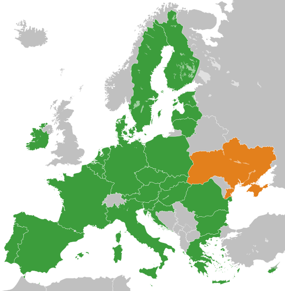
File:European Union Ukraine Locator.svg

Size of this PNG preview of this SVG file: 587 × 600 pixels. Other resolutions: 235 × 240 pixels | 470 × 480 pixels | 752 × 768 pixels | 1,002 × 1,024 pixels | 2,004 × 2,048 pixels | 593 × 606 pixels.
Original file (SVG file, nominally 593 × 606 pixels, file size: 711 KB)
File history
Click on a date/time to view the file as it appeared at that time.
| Date/Time | Thumbnail | Dimensions | User | Comment | |
|---|---|---|---|---|---|
| current | 13:40, 20 November 2022 |  | 593 × 606 (711 KB) | M.Bitton | Reverted to version as of 01:53, 19 November 2022 (UTC): per COM:OVERWRITE. 2016 was 6 years ago, making this map stable. Feel free to upload under a different name |
| 08:48, 20 November 2022 |  | 593 × 606 (712 KB) | Рагин1987 | Removed the gray square at the maritime borders of Spain. Slightly expanded the map to the borders of Georgia (the territory of Abkhazia), since Georgia, like Moldova, is a member of the Eastern Partnership, an associated trio and applied for EU membership. Please, before automatically referring to COM:OVERWRITE, take a close look at the history of the file, and the fact that its format was radically edited in 2016. | |
| 01:53, 19 November 2022 |  | 593 × 606 (711 KB) | M.Bitton | Reverted to version as of 14:42, 3 July 2020 (UTC): meaningless edit summary | |
| 13:06, 18 November 2022 |  | 593 × 606 (710 KB) | Рагин1987 | Small correction | |
| 14:42, 3 July 2020 |  | 593 × 606 (711 KB) | Halbgeviertstrich | Reverted presumably accidental colour change for Malta | |
| 12:42, 5 February 2020 |  | 593 × 606 (711 KB) | Darranc | Reverted to version as of 11:57, 3 February 2020 (UTC) - UK isn't in the EU. This file name is a Ukraine locator in relation to the EU | |
| 17:22, 3 February 2020 |  | 593 × 606 (711 KB) | L.tak | update UK (former member, colour #123456, still applies the treaty in transition phase) | |
| 17:14, 3 February 2020 |  | 680 × 520 (604 KB) | L.tak | Reverted to version as of 18:15, 26 October 2016 (UTC): Still applicable in the UK during transition phase | |
| 11:57, 3 February 2020 |  | 593 × 606 (711 KB) | Darranc | Remove UK from EU | |
| 18:15, 26 October 2016 |  | 680 × 520 (604 KB) | Giorgi Balakhadze | Rv of sockpuppet and per COM:OVERWRITE |
File usage
The following 40 pages use this file:
- Accession of Ukraine to the European Union
- Ukraine–European Union relations
- User:+JMJ+
- User:A.h. king/Userbox/No EU enlargement Ukraine
- User:Ahri Boy
- User:AlonsoRiveraM
- User:Balkanian`s word
- User:BathTubJesus
- User:Biletsky Volodymyr
- User:Bolegash
- User:Bouncingnewsgreen
- User:Constraque
- User:Deavenger
- User:Dirtybutclean
- User:EllsworthSK
- User:Gggh
- User:Idaltu
- User:JaikeV
- User:Julianhayda
- User:K9re11
- User:Liegger
- User:Lionheart Omega
- User:MAXXX-309
- User:Manuela Listkiewska
- User:Michalgill
- User:Narking
- User:Nickispeaki
- User:Nomadbones
- User:Oleh Kushch
- User:PKLion
- User:Patersonp6
- User:Smart30
- User:Temujin321
- User:TheTurtleHistorian
- User:Yulia Romero
- User:Yulia Romero/OpinionsOfYulia Romero
- User:Yulia Romero/Userbox/EU enlargement Ukraine
- User talk:A Nobody/Deletion discussions
- Wikipedia:Userboxes/Politics/Multinational/European Union
- Wikipedia:Userboxes/Politics by country/Ukraine
Global file usage
The following other wikis use this file:
- Usage on ar.wikipedia.org
- Usage on ca.wikipedia.org
- Usage on de.wikipedia.org
- Usage on eo.wikiquote.org
- Usage on es.wikipedia.org
- Usage on et.wikipedia.org
- Usage on eu.wikipedia.org
- Usage on fi.wikipedia.org
- Usage on fr.wikipedia.org
- Usage on fr.wikinews.org
- Usage on ga.wikipedia.org
- Usage on he.wikipedia.org
- Usage on hu.wikipedia.org
- Usage on hy.wikipedia.org
- Usage on id.wikipedia.org
- Usage on it.wikipedia.org
- Usage on ka.wikipedia.org
- Usage on ko.wikipedia.org
- Usage on lt.wikipedia.org
- Usage on lv.wikipedia.org
- Usage on mk.wikipedia.org
- Usage on nl.wikipedia.org
- Usage on pl.wikipedia.org
- Usage on pt.wikipedia.org
- Usage on ro.wikipedia.org
- Usage on ru.wikipedia.org
View more global usage of this file.
