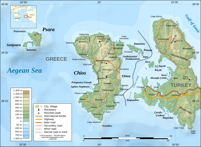
File:Chios topographic map-en.svg

Size of this PNG preview of this SVG file: 800 × 582 pixels. Other resolutions: 320 × 233 pixels | 640 × 466 pixels | 1,024 × 745 pixels | 1,280 × 932 pixels | 2,560 × 1,863 pixels | 1,580 × 1,150 pixels.
Original file (SVG file, nominally 1,580 × 1,150 pixels, file size: 1.4 MB)
File history
Click on a date/time to view the file as it appeared at that time.
| Date/Time | Thumbnail | Dimensions | User | Comment | |
|---|---|---|---|---|---|
| current | 17:15, 27 January 2022 |  | 1,580 × 1,150 (1.4 MB) | Pinacotecus | File uploaded using svgtranslate tool (https://svgtranslate.toolforge.org/). Added translation for en. |
| 17:10, 27 January 2022 |  | 1,580 × 1,150 (1.4 MB) | Pinacotecus | File uploaded using svgtranslate tool (https://svgtranslate.toolforge.org/). Added translation for en. | |
| 16:55, 27 January 2022 |  | 1,580 × 1,150 (1.4 MB) | Pinacotecus | Uploaded a work by Eric Gaba (translated by Pinacotecus (talk)) from Image:Chios topographic map-fr.svg with UploadWizard |
File usage
The following 5 pages use this file:
Global file usage
The following other wikis use this file:
- Usage on bg.wikipedia.org
- Usage on el.wikipedia.org
- Usage on hr.wikipedia.org
- Usage on ig.wikipedia.org
- Usage on incubator.wikimedia.org
- Usage on it.wikipedia.org
- Usage on lij.wikipedia.org
- Usage on pl.wikipedia.org
- Usage on sl.wikipedia.org


