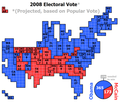
File:Cartogram-2008 Electoral Vote.png

Size of this preview: 705 × 599 pixels. Other resolutions: 282 × 240 pixels | 565 × 480 pixels | 1,000 × 850 pixels.
Original file (1,000 × 850 pixels, file size: 56 KB, MIME type: image/png)
File history
Click on a date/time to view the file as it appeared at that time.
| Date/Time | Thumbnail | Dimensions | User | Comment | |
|---|---|---|---|---|---|
| current | 03:59, 9 January 2009 |  | 1,000 × 850 (56 KB) | ChrisnHouston | {{Information |Description=Cartogram of the 2008 Electoral Vote for US President, with each square representing one electoral vote. Nebraska, being one of two states that are not winner-take-all, for the first time had its votes split, with NE-2 voting fo |
| 22:03, 19 November 2008 |  | 1,000 × 850 (61 KB) | Collegebookworm | update of existing cartogram for missouri projections | |
| 23:18, 10 November 2008 |  | 1,000 × 850 (39 KB) | ChrisnHouston | {{Information |Description={{en|1=Cartogram of the projected 2008 Electoral Vote for US President (based on popular vote) with each square representing one electoral vote. Nebraska, being one of two states that are not winner-take-all, for the first time |
File usage
The following 4 pages use this file:
Global file usage
The following other wikis use this file:
- Usage on es.wikipedia.org
- Usage on ja.wikipedia.org
- Usage on mk.wikipedia.org
- Usage on no.wikipedia.org
- Usage on ru.wikipedia.org
- Usage on vi.wikipedia.org


