Langbahn Team – Weltmeisterschaft

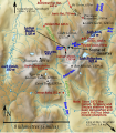
File:Cairngorm relief map for 1971 disaster.svg

Original file (SVG file, nominally 712 × 811 pixels, file size: 904 KB)

Summary

Description
English: Map identifying points relevant to the 1971 Cairngorm Plateau Disaster. This map has been derived from the base map specified here. This file was derived from: Central Cairngorms UK relief map.png
.
Date
Source Own work
Author Thincat
SVG development
InfoField
 
The SVG code is valid.
 
This map was created with Inkscape, or with something else.
 
  This SVG map uses embedded raster graphics to show its topographic structures.
 
The file size of this SVG map may be irrationally large because its text has been converted to paths inhibiting translations.
Camera location57° 05′ 20″ N, 3° 40′ 40″ W Kartographer map based on OpenStreetMap.View this and other nearby images on: OpenStreetMapinfo

Licensing

I, the copyright holder of this work, hereby publish it under the following license:
w:en:Creative Commons
attribution share alike
This file is licensed under the Creative Commons Attribution-Share Alike 4.0 International license.
You are free:
  • to share – to copy, distribute and transmit the work
  • to remix – to adapt the work
Under the following conditions:
  • attribution – You must give appropriate credit, provide a link to the license, and indicate if changes were made. You may do so in any reasonable manner, but not in any way that suggests the licensor endorses you or your use.
  • share alike – If you remix, transform, or build upon the material, you must distribute your contributions under the same or compatible license as the original.

Captions

Add a one-line explanation of what this file represents

Items portrayed in this file

depicts

creator

some value

author name string: Thincat
Wikimedia username: Thincat

copyright status

copyrighted

copyright license

Creative Commons Attribution-ShareAlike 4.0 International

inception

21 February 2016

source of file

original creation by uploader

coordinates of the point of view

57°5'20.000"N, 3°40'40.001"W

media type

image/svg+xml

checksum

625568bfee4fe69161dcfd47961b5e3987513fb0

determination method or standard: SHA-1

data size

925,296 byte

height

811 pixel

width

712 pixel

File history

Click on a date/time to view the file as it appeared at that time.

(newest | oldest) View (newer 10 | ) (10 | 20 | 50 | 100 | 250 | 500)
Date/TimeThumbnailDimensionsUserComment
current10:27, 12 April 2016Thumbnail for version as of 10:27, 12 April 2016712 × 811 (904 KB)ThincatJean's Hut had been moved by 1971
20:43, 11 April 2016Thumbnail for version as of 20:43, 11 April 2016712 × 811 (901 KB)ThincatCorrect the elevation of Pools of Dee
09:17, 9 April 2016Thumbnail for version as of 09:17, 9 April 2016712 × 811 (916 KB)ThincatMark Pools of Dee
09:06, 9 April 2016Thumbnail for version as of 09:06, 9 April 2016712 × 811 (902 KB)ThincatCurran shelter on south shore of Lochan Buidhe
08:57, 14 March 2016Thumbnail for version as of 08:57, 14 March 2016712 × 811 (889 KB)ThincatMore accurate locations
14:10, 2 March 2016Thumbnail for version as of 14:10, 2 March 2016712 × 811 (852 KB)ThincatAdd Shelter Stone
13:30, 2 March 2016Thumbnail for version as of 13:30, 2 March 2016712 × 811 (839 KB)ThincatUpdate bothy information
23:20, 21 February 2016Thumbnail for version as of 23:20, 21 February 2016712 × 811 (768 KB)ThincatMore accurate location for disaster
22:45, 21 February 2016Thumbnail for version as of 22:45, 21 February 2016712 × 811 (768 KB)Thincatupdate warning about shelters
22:34, 21 February 2016Thumbnail for version as of 22:34, 21 February 2016712 × 811 (768 KB)ThincatAdded St Valery shelter
(newest | oldest) View (newer 10 | ) (10 | 20 | 50 | 100 | 250 | 500)

The following page uses this file:

Global file usage

The following other wikis use this file:

Metadata